20 Setting Up Zones for Batch Pipeline Rating
This chapter describes how to set up zones for Oracle Communications Billing and Revenue Management (BRM) Pipeline Manager.
For information about Pipeline Manager, see "About pipeline rating" in BRM Configuring Pipeline Rating and Discounting.
About Zoning
Zoning adds call data to EDRs that can be used for rating. A zone is a combination of origin and destination area codes. You create zones to rate calls based on their origin and destination. You can also define zones for different services. For example, you can create zones for rating:
-
Local calls.
-
National calls.
-
International calls.
-
Wholesale rating of roaming usage.
-
National calls for specific services such as SMS.
There are two types of zones:
-
Standard zones. These are determined by evaluating the area code of the calling number (the A number) and the called number (the B number). See "About Standard Zones".
-
Geographical zones. These are determined by evaluating the distance between the origin and destination of the calls. See "About Geographical Zones".
All zones are mapped to impact categories. You combine impact categories with service usage data to create the final impact categories used by Pipeline Manager as the primary rating attribute. For more information, see "About Impact Categories".
When you configure zones in Pricing Center, you configure the following:
-
Standard zones.
-
Geographical zones.
-
APN maps (for rating GPRS events).
-
Zone models, which are collections of zones.
-
Impact categories.
About Impact Categories
You use Pipeline Manager impact categories to rate calls based on event attributes such as call origin and destination, and service attributes such as call forwarding. For example, you can create impact categories to rate:
-
Local calls.
-
Long distance calls.
-
Local call forwarding.
-
Long distance call forwarding.
-
Local mailbox inquiries.
-
National mailbox inquiries.
You create an impact category for each zone and usage scenario that you define. A usage scenario describes the type of call, for example, a long-distance mailbox inquiry. You map the following data to impact categories:
-
In zone mapping, a zone and service code. The impact category and zone name are the same.
-
In usage scenario mapping, a service code, service class, usage class, usage type, and zone.
You must define all possible impact categories before you can use them in a zone model. Before defining impact categories, it is helpful to know the following:
-
How many and what kinds of zones you must configure, for example:
-
Domestic zones and international zones.
-
Zones for rating all wireless usage types or for specific usage types only, such as telephony, fax, and SMS.
-
Zones for rating retail usage and roaming usage.
-
No-charge zones such as toll-free and emergency destinations.
-
-
How many and what kind of usage scenarios you must configure, for example:
-
Mailbox inquiries
-
Conference calling
-
Call forwarding
-
Family and friends calls
-
Your impact category names should reflect the usage scenario. For example, if you offer service-level agreements, you might create three impact categories called Bronze, Silver, and Gold.
For more information on creating usage scenarios, see "Setting Up Usage Scenario Mapping".
About Wholesale and Retail Impact Categories
An impact category can be used for either wholesale rating or retail rating. Retail rating applies to usage by your subscribers on your network. Wholesale rating applies to usage by visiting subscribers, for example, roaming calls.
You define impact categories according to your retail and wholesale needs. However, when you create impact categories, you do not specify whether they are used for wholesale or retail rating. Instead, you enter the impact category name in the wholesale and retail impact categories or zone fields when configuring zones and usage scenarios. You must enter values for both wholesale and retail impact categories and zones. When calls are rated, the type of impact category used is determined by whether the rate plan model type is wholesale or retail.
About Standard Zones
A standard zone is a combination of an origin and destination area code and one or more services such as telephony and SMS. You assign an impact category to each zone that you define. For example, in Table 20-1, telephony origin and destination area codes are mapped to one of three impact categories; Local, Toll, and LongDistance:
About Geographical Zones
A geographical zone is the distance between the origin and destination of a call. You set up geographical zones to rate calls by distance. This is useful when:
-
Customers are located very near the border between two area codes. For example, if a customer in one area code calls a person two blocks away in another area code, you do not want to charge for a long-distance call.
-
The distance covered by an area code is very large and you want to use several rates within the same area code. You do this by mapping sets of latitude and longitude coordinates to the same area code in a geographical model.
To set up geographical zones:
-
Define geographical zones and map them to distances.
-
Create geographical models to:
-
Define the area codes that make up each zone.
-
Map latitude and longitude coordinates to area codes.
-
Geographical mapping uses the area codes and geographic coordinates to compute the distance and assigns the zone that matches that distance to the call record.
Displaying Zoning Information on an Invoice
You can enter a zone description that can be included in invoices. To do so, in Pricing Center, enter the zone description in the Description field in the following dialog boxes:
-
Standard Zone
-
Geographical Zone
-
Usage Scenario Mapping
You can use a maximum of 2,000 characters in the description.
Important:
To include zone descriptions on your invoices, you must configure the DAT_Zone and the FCT_USC_Map modules to load invoice description data into memory.About Pipeline Manager Zone Modules
Zoning is performed by the following function and data modules:
-
The FCT_APN_Map module adds Access Point Name (APN) data for the following:
-
To define zones.
-
To adjust impact categories.
-
-
The FCT_PreRating module calculates zones and creates impact categories. This is the primary zoning module. See "Setting Up Prerating".
-
The FCT_USC_Map module adjusts zones based on service attributes. See "Setting Up Usage Scenario Mapping".
-
The DAT_Zone module handles zoning data for the zoning function modules.
The following function and iScript modules are used for optional zoning features:
-
The FCT_Zone module calculates zones when you run Pipeline Manager for real-time zoning.
-
The FCT_SegZoneNoCust maps zone models to segments. Use segment rating for collecting business information, for example, comparing the charges for the same events by using different rate plans.
-
The FCT_MainZoning performs zoning for segment rating. It is used when a pipeline is used only for zoning.
-
The ISC_SetSvcCodeRTZoning iScript updates DETAIL.INTERN_SERVICE_CODE EDR field with the customized service code value when different service codes are mapped to the same service type in the pipeline database and a specific service code is used in the zoning table.
About Zone Models
Every zone and usage scenario is mapped to an impact category. You create zone models to define the set of zones and impact categories available in the rate plan. For example, if you have a wireless rate plan that includes mailbox inquiries and SMS messaging, your zone model might include the following:
-
Zones that map in-network area codes.
-
Zones that map in-network area codes to area codes in your roaming partner networks.
-
Usage scenario maps for mailbox inquiries.
-
Usage scenario maps for SMS usage.
Your zone models can be simple or complex, depending on your business needs. For example, you might create just one zone model that includes all possible usage scenarios or many zone models that group more specific usage scenarios.
About Hierarchical Zone Models
You can also optionally create hierarchical zone models by linking them. Hierarchical zone models are useful for customizing zones for particular customers. For example, if a company has an office overseas, you might want to use a special rate for calls between the home and remote offices while using the standard rate for all other within the same zone.
Hierarchical zone models also enable you to reuse zone models in different usage configurations, for example:
-
You can include a zone model for rating Friends and Family calls in zone models for telephony usage.
-
You can include a national zone model in an international zone model.
-
You can include a geographical zone model inside a standard zone model to use several rates within the same area code. For more information, see "About Geographical Zones".
You can create as many levels of nested zone models as you like.
Figure 20-1 shows a hierarchy of zone models for rating calls originating in Germany:
Figure 20-1 Zone Model Hierarchy for Calls Originating in Germany
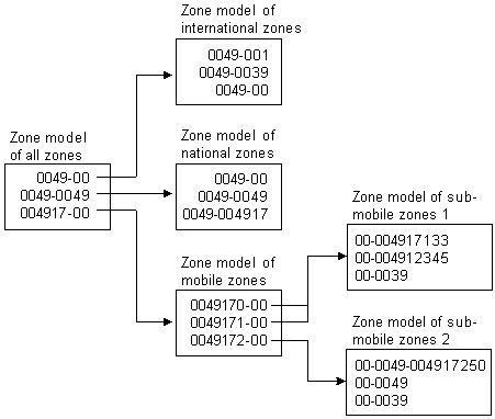
Description of ''Figure 20-1 Zone Model Hierarchy for Calls Originating in Germany''
Setting Up Zone Models
When you configure zone models in Pricing Center, you configure the following:
-
Standard zones
-
Geographical zones
-
Usage scenario maps
To create zone models in Pricing Center, you complete these tasks:
-
Create impact categories for every zone and usage scenario you plan to define.
-
Create a zone model. You must create a zone model before you can create zones.
-
Create standard zones to map area code combinations.
-
If necessary, create geographical zones by performing these tasks:
-
Create geographical zones to map distance to impact categories.
-
Create geographical models to map area codes to longitude and latitude coordinates.
-
-
Create usage scenarios maps to map usage-specific data to impact categories.
For more information, see Pricing Center Help.
Setting Up APN Mapping
Use the FCT_APN_Map module to rate GPRS events. The module runs before zoning or after zoning:
-
Before zoning. If you rate calls that access a GPRS data service, for example, to download content, there is no B number. In that case, the module runs before zoning. It maps the access point name (APN) to a packet data protocol (PDP) which serves as the B number that can be used for zoning.
-
After zoning. If you rate GPRS calls made from one phone to another, for example, to exchange calendar appointments, the EDR includes the A number and B number. In this case, the zoning module has already created an impact category from the A number and B number. The FCT_APN_Map module uses the access point name (APN) to modify the wholesale and retail impact categories.
To configure APN mapping, you do the following:
-
Create APN maps. See "About APN Maps".
-
Configure the FCT_APN_Map module.
About APN Maps
To map APN numbers to PDPs before zoning or to impact categories after zoning, the FCT_APN_Map module reads data from the EDR and evaluates it according to the APN map. An APN map includes one or more mapping rules that specify the data that must be matched to apply the mapping.
You can create multiple sets of APN mapping rules, for example, different mappings for wholesale and retail rating.
You can use APN groups to assign a set of rules to a specific FCT_APN_Map module instance.
You can use the following EDR data to create an APN mapping rule:
-
These values are compared with the EDR data when the module runs before or after zoning:
-
APN name (from the Associated GPRS Extension record APN_ADDRESS field)
-
Internal service code
-
-
These values are compared with the EDR data only when the module runs after zoning:
-
Wholesale zone
-
Retail zone
-
You rank APN mapping rules when you create them. The first rule that matches the EDR data is used. The results of the mapping add the following data to the EDR:
-
If the module runs before zoning, it adds the PDP address in the detail record INTERN_B_NUMBER_ZONE field.
-
If the module runs after zoning, it adds the following:
-
Impact category
-
Wholesale zone
-
Resale zone
-
When you run the FCT_APN_Map module after zoning, different EDR fields are used depending on whether you use FCT_PreRate for zoning and rating, or FCT_Zone for zoning only:
-
When FCT_PreRate is used (for zoning and rating):
-
The impact category is read from and written to the associated charge breakdown record.
-
The wholesale and retail zones are read from and written to the supplementary zone packet record.
-
-
When FCT_Zone is used (for zoning only), the wholesale and retail zones are read from and written to the detail block of the EDR.
The following tables summarize the data mappings.
Table 20-2 describes the EDR field mapping before zoning when there is no B number.
Table 20-2 Running FCT_APN_Map before Zoning
| EDR Field | Compared against This Pipeline Manager Database Field |
|---|---|
|
AssocCharge-APN group |
IFW_APN_MAP.APN_GROUP |
|
Detail-Internal Service Code |
IFW_APN_MAP.SERVICECODE |
|
Detail-Application |
IFW_APN_MAP.ACCESSPOINTNAME |
Running FCT_APN_Map after zoning:
For every zone breakdown record the following mapping is performed as shown in Table 20-3:
Table 20-3 Running FCT_APN_Map after Zoning
| EDR Field | Compared against This Database Field |
|---|---|
|
AssocZone-APN group |
IFW_APN_MAP.APN_GROUP |
|
Detail-Internal Service Code |
IFW_APN_MAP.SERVICECODE |
|
Detail-Application |
IFW_APN_MAP.ACCESSPOINTNAME |
|
AssocZone-Wholesale Zone Result value |
IFW_APN_MAP.ZONE_WS |
|
AssocZone-Retail Zone Result value |
IFW_APN_MAP.ZONE_RT |
Creating APN Maps
Use Pricing Center to create APN maps and APN groups. APN groups are assigned differently depending on whether you run the FCT_APN_Map module before or after zoning:
-
Before zoning. Specify the APN map in the APNGroup registry setting.
-
After zoning. Specify the APN map in the zone model.
When you create mapping rules, you use regular expressions. See Pricing Center Help for more information.
Setting Up Prerating
Prerating is performed by the FCT_PreRating module. This module uses the data in the EDR to compute zones and assign an impact category to each charge packet.
The module works as follows:
-
It finds the rate plan to use by reading the rate plan code in the charge packet.
Note:
When an EDR is associated with multiple rate plans, FCT_PreRating uses the highest priority rate plan. That is, it searches through all associated rate plans, from highest priority to lowest priority, until it finds a plan that matches the event's criteria. When two rate plans have matching priority, FCT_PreRating chooses the rate plan with the earliest start time. -
In the rate plan, it finds the zone model.
-
It uses the zone model to calculate the zone and write the impact category to the charge packet. It reads the following information in the EDR:
-
Service code
-
A number
-
B number
-
Call start timestamp
The data used for determining zones and impact categories is handled by the DAT_Zone module. You configure the data by using Pricing Center.
-
To set up prerating, you do the following:
-
Create zone models and impact categories in Pricing Center.
You can also define zone data for the DAT_Zone module in ASCII files. See "Creating Zone Data Files".
Important:
You can use DAT_Zone in file mode in an FCT_Zone/DAT_Zone combination only. Because file-based zoning cannot coexist with pre-rating, DAT_Zone in file mode does not work with FCT_PreRating. -
Configure the FCT_PreRating module.
-
Configure the DAT_Zone module.
For information about configuring pipeline modules, see "Configuring Pipeline Rating" in BRM Configuring Pipeline Rating and Discounting.
Creating Zone Data Files
Zone data can be defined in ASCII files.
-
Each line in a file contains one configuration entry.
-
Fields are separated by semicolons (;).
Master Data File
Master data files defines the zone model codes in the format:
ZoneModelCode;ZoneModelType;GeoModel
where:
ZoneModelCode specifies a unique code for the zone model.
ZoneModelType specifies the zone model type; standard (S) or geographical (G).
GeoModel specifies the geographical link.
Master data file example:
ZM_ADD;S;100000
ZM_GEO;G;100000
Standard Zone File
Standard zone file defines standard zone models in the format:
ServiceCode;ValidFrom;ValidTo;Origin;OriginDesc;Destination;DestinationDesc;RtZone;WsZone;ZoneEntryName;ZoneDescription;AltZoneModel
where:
ServiceCode is the service code that applies to the zone.
ValidFrom is the date when the standard zone becomes valid, in the format DD.MM.YYYY. For example, 31.12.2004.
ValidTo is the date when the standard zone becomes inactive. Use the same date format as above.
Origin is the origin area code for the zone.
OriginDesc is the description for the origin.
Destination is the destination area code for the zone.
DestinationDesc is the description for the destination.
RtZone is the impact category for retail rating to apply to the zone.
WsZone is the impact category for wholesale rating to apply to the zone.
ZoneEntryName is the name for the standard zone.
ZoneDescription is the description for the standard zone.
AltZoneModel is the alternate standard zone model that can be used.
Important:
The ZoneEntryName and ZoneDescription fields must be included, even if they are not used.Standard zone file example:
TEL;20030101;;0049;Germany;0049;Germany;NAT_MBI;NAT_MBI;;;
Geographical Zone File
Geographical zone file defines geographical zone models in the format:
Distance;ServiceCode;ValidFrom;ValidTo;WsZone;RtZone;ZoneEntryName;ZoneDescription;AltZoneModel
where:
Distance is the maximum distance for the geographical zone.
ServiceCode is the service code that applies to the zone.
ValidFrom is the date when the zone becomes valid, in the format DD.MM.YYYY. For example, 31.12.2004.
ValidTo is the date when the zone becomes inactive. Use the same date format as above.
WsZone is the impact category for wholesale rating to apply to the zone.
RtZone is the impact category for retail rating to apply to the zone.
ZoneEntryName is the name for the geographical zone.
ZoneDescription is the description for the geographical zone.
AltZoneModel is the alternate geographical zone model that can be used.
Important:
The ZoneEntryName and ZoneDescription fields must be included, even if they are not used.Geographical zone file example:
500;*;19990101;;NAT_FIX;NAT_FIX;;;
Area Code Coordinate File
Area code coordinate file defines area codes used in a geographical zone in the format:
GeoModel;AreaCode;Longitude;Latitude;ValidFrom;ValidTo
where:
GeoModel is the description for the geographical link.
AreaCode is the area code to link.
Longitude is the longitude for the area code.
Latitude is the latitude for the area code.
ValidFrom is the date when the geographical link becomes valid, in the format DD.MM.YYYY. For example, 31.12.2004
ValidTo is the date when geographical link becomes inactive. Use the same date format as above.
Area code coordinate file example:
100000;049;80;80;19990101;19990115
About Usage Scenario Mapping
Usage scenario mapping brings together the data in all EDR fields pertaining to the service code, usage class, usage type, and zone, and then adds the final impact category used for rating the EDR to the charge packet or the detail block, depending on which USC mapping mode you selected as shown in Figure 20-2.
Figure 20-2 Usage Scenario Mapping Factors
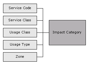
Description of ''Figure 20-2 Usage Scenario Mapping Factors''
The impact category is included as part of the rate plans.
You define usage scenario mapping to rate differentiated network services, such as mailbox inquiries and friends-and-family discounts.
For example:
-
If a customer has a mailbox service, you can create separate impact categories for accessing a mailbox from your network or from a different carrier's network. In this example, the impact category uses two values, the usage class that represents the mailbox, and the zone that the event applies to.
-
If you provide a friends-and-family discount, you can create separate impact categories for national friends and international friends.
-
If a customer has call forwarding, you can create separate impact categories for calls forwarded to a local number or to a long-distance number.
You can use multiple attributes to define an impact category, or you can use only one attribute.
Tip:
You can use iScript to define your own attributes to be considered when specifying the final impact category. See "Creating iScripts and iRules" in BRM Developer's Guide.Setting Up Usage Scenario Mapping
To set up usage scenario mapping, do the following:
-
Create usage scenario maps. You have two options:
-
You can create usage scenario maps in Pricing Center. In this case, the usage scenario map data is stored in the Pipeline Manager database.
-
You can create a file that defines usage scenario maps. In this case, the FCT_USC_Map module reads the file. For information on creating the file, see "Creating a Usage Scenario Map File".
-
-
Configure the FCT_USC_Map module.
You specify the mode in which USC mapping is done.
-
The Rating mode (the default) specifies that USC mapping is done using the zone model from the charge packets. Mapping in this mode provides the impact category for charge packets.
-
The Zoning mode specifies that USC mapping is done using the zone model from the EDR detail block. Mapping in this mode provides impact categories for the detail block.
-
-
Configure the DAT_USC_Map module.
When you use the database interface, you create USC map groups in Pricing Center, which contain the USC maps. You associate USC map groups with zone models. FCT_USC_Map uses the zone model ID in the EDR to identify the associated USC map group. The zone model ID is added to the EDR by the FCT_PreRating module. See "Setting Up Prerating".
Note:
If there is no zone value in the EDR, FCT_USC_Map writes an empty string as the value of the zone to the output EDR. This should be considered when you set up the mapping.Tip:
You can use semaphore commands with the DAT_USC module to save USC Map data to a file.-
Use PrintAllUscMapData to save all of the USC Map data to a file.
-
Use PrintUscMapDataForZoneModel to save the data for a specified Zone Model ID.
-
Use PreCompiledDataDir to compile USC mapping data and save the data to a specified directory.
-
Use NumberOfThreads to specify the number of threads to use when compiling and loading the mapping data.
-
Use UscGroups to specify the USC groups for which to load rules.
-
About Usage Scenario Maps
Usage scenario mapping is performed by the FCT_USC_Map module. To define the final impact category, the module reads data from the EDR and evaluates it according to the usage scenario map. A usage scenario map includes one or more mapping rules that specify the data that must be matched to apply the impact category.
When you create usage scenario maps, you create a mapping rule for each impact category. You can also define the order in which the rules are evaluated. The impact category is derived from the first rule that matches the data. If no matching rule is found in the usage scenario mappings, then no mapping is performed.
When no usage scenario mappings are set up, FCT_USC_Map module uses the default USC map group. To use a default USC map group, you must create it and specify the default USC map group in the FCT_USC_Map registry.
You can use the following data to create a mapping rule:
-
The EDR date and time. This data is read from the EDR StartTimeStamp field.
-
Maximum event quantity, for example, 60 seconds. If the quantity exceeds this value, the map does not apply.
-
Minimum and maximum wholesale amount.
-
Usage class.
-
Usage type.
-
Service code.
-
Service class.
-
Wholesale and retail impact category.
When you create the mapping rules, you use regular expressions.
Creating a Usage Scenario Map File
The USC mapping rules are defined in an ASCII file.
-
Each rule consists of a list of fields. The following table describes the meaning of each field.
-
Every new line defines an adjustment rule.
-
The position of each rule in the file determines its rank. The first matching rule is used.
-
Fields are separated by semicolons (;).
-
Comment lines start with #.
-
Empty lines are allowed.
Important:
The value of the field rank is ignored. The evaluation order of the rules is given by the order of the rules within the file.
Table 20-4 lists the fields in the file:
Table 20-4 Fields in Usage Scenario Mapping File
| Position | Identifier | Description |
|---|---|---|
|
1 |
USCGroup |
Specifies the compare pattern for the source USC group. |
|
2 |
Rank |
This parameter is not evaluated. Instead, the rules are evaluated in the order they appear in the file. |
|
3 |
ValidFrom |
Specifies the start date for the USC mapping rule. This can either be a date with the format YYYYMMDD or a weekday with an optional timestamp, for example:
If the field is left empty, the earliest possible date 19010101 is used. |
|
4 |
ValidTo |
Specifies the end date for the USC mapping rule. This can either be a date with the format YYYYMMDD or a weekday with an optional timestamp. If the field is left empty, the latest possible date 20370205 is used. |
|
5 |
TimeFrom |
Specifies the beginning of the time period (in format HH:MM) the mapping entry is valid on each day of the validity period specified by ValidFrom and ValidTo. If the field is left empty, 00:00 is used. |
|
6 |
TimeTo |
Specifies the end of the time period (format HH:MM) the mapping entry is valid on each day of the validity period specified by ValidFrom and ValidTo. If the field is left empty, 24:00 is used. Example: To set up a mapping entry that is valid on weekends between 13:00 and 14:00, you must set ValidFrom=SAT, ValidTo=SUN, TimeFrom=13:00 and TimeTo=14:00. |
|
7 |
Quantity |
Specifies the maximum quantity value for an EDR container. If this maximum is exceeded, the mapping rule will not be used. If this field is left empty or a 0 is specified, the rule is valid for every quantity value. For example, to avoid mapping for calls longer than 60 seconds, set the value to 60. |
|
8 |
MinAocAccount |
Specifies the optional minimal wholesale amount value (the wholesale charge). The map is valid only if the EDR charge value is greater or equal to this setting. |
|
9 |
MaxAocAccount |
Specifies the optional maximum wholesale amount value (the wholesale charge). The map is valid only if the EDR charge value is less than or equal to this setting. |
|
10 |
SourceUsageClass |
Specifies the compare pattern for the source usage class. |
|
11 |
SourceUsageType |
Specifies the compare pattern for the source usage type. |
|
12 |
SourceServiceCode |
Specifies the compare pattern for the source service code. |
|
13 |
ServiceClass |
Specifies the compare pattern for the source service class. |
|
14 |
SourceImpactCategoryWS |
Specifies the compare pattern for the source wholesale impact category |
|
15 |
SourceImpactCategoryRT |
Specifies the compare pattern for the source retail impact category. |
|
16 |
NewUsageType |
Specifies the resulting usage type for this rule. If this field is left blank or set to 0, the usage type is not modified. |
|
17 |
NewImpactCategoryWS |
Specifies the compare pattern for the wholesale zone which should be mapped. |
|
18 |
NewImpactCategoryRT |
Specifies the compare pattern for the retail zone which should be mapped. |
|
19 |
Description |
Specifies the rule name. It is not used for rule evaluation. |
Converting Zone Values for Output
Use an IRule script to convert the alphanumeric zone values (impact category name) into external result values before the EDR container is written to the output file. Be default, the IMPACT_CATEGORY values from IFW_IMPACT_CAT are written to the output file as the zone value.
Setting Up Multi-Segment Zoning
Use multi-segment zoning to test different zoning models against the same EDR data. Use the FCT_SegZoneNoCust module and the FCT_MainZoning module to perform zoning for multi-segment zoning.
Use the FCT_SegZoneNoCust module to perform zoning when you cannot get customer account data about the EDRs. For example, you might want to use a test system that does not have access to account data. In that case, you configure the FCT_SegZoneNoCust module to find the segment based on the source network ID.
After the FCT_SegZoneNoCust module finds the segment, it adds the zone data for that segment to the EDR. It adds one associated zone breakdown record for each zone in the segment. The FCT_MainZoning module uses this data to perform the zoning and add the results to the zone packets.
To configure multi-segment zoning, configure the FCT_SegZoneNoCust and FCT_MainZoning modules.
Configuring Segments in the FCT_SegZoneNoCust Module
Use the FCT_SegZoneNoCust module Segments registry entry to specify the segment to use for each source network. Each rule defines the connection between the source network and the segment. For example:
26201 = SegmentD1
26202 = SegmentD2
Important:
You cannot change these mappings during run time.