11g Release 7 (11.1.7)
Part Number E20372-07
Home
Contents
Book
List
Contact
Us
|
Oracle® Fusion Applications Marketing Implementation Guide 11g Release 7 (11.1.7) Part Number E20372-07 |
Home |
Contents |
Book List |
Contact Us |
|
Previous |
Next |
This chapter contains the following:
Territory Components: How They Work Together
Define Territory Management Dimensions
FAQs for Manage Territory Management Synchronization
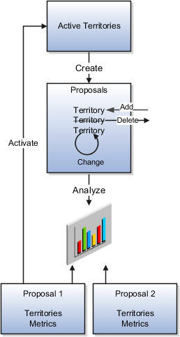
Territories are used to define the jurisdiction of responsibility of a salesperson over a set of sales accounts. Sales managers use territory proposals to change territory definitions. Managers can create more than one territory proposal and use metrics and graphs to compare and analyze their proposed territories for fairness, effectiveness, and alignment with current sales goals. Managers then activate the best territory proposals.
This figure shows the use of territory proposals to add, change, and delete territories. After analysis, managers activate final territory proposals.
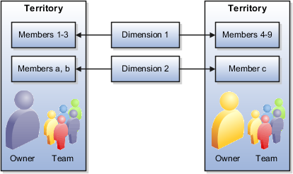
A territory, whether active or part of a territory proposal, includes several elements. One or more dimensions, such as geography, define the boundaries of a territory according to selected dimension members, such as Europe or Asia. Every territory is assigned an owner and can have additional territory team members.
This figure shows two territories defined using the same two dimensions but different dimension members. Each territory has an owner and a sales team.
Dimensions are attributes that define jurisdictional boundaries of territories. For example, the geography dimension can be used to define territories by country or postal code. Territory dimensions are used to assign sales accounts, partners, leads, and opportunities to the correct territories.
Each territory dimension is matched to an attribute of the object being assigned. Product and Sales Channel dimensions are matched to lead and opportunity attributes directly. The rest of the dimensions are matched to sales account attributes either when assigning sales accounts to territories, or when assigning leads and opportunities to territories, in which case the sales account for the transaction is used. All dimension values combine to define the territory boundaries. For example, if Geography = United States and Product = Green Servers, then the territory boundaries are United States AND Green Servers.
The dimensions available for defining territories are:
Account
Account Type
Named or Not Named
Customer Size
From the Organization Size lookup
Geography
Industry
Organization Type
The organization type hierarchy is from the customer classification module.
Partner
Product
A hierarchy from the Sales Catalog. Used to assign leads and opportunities, but not accounts.
Sales Channel
Used to assign leads and opportunities, but not accounts.
Auxiliary 1, 2, 3
Your administrator enables the dimensions your organization uses for defining territories. The administrator also selects the dimension members that appear in the selection list when defining territory dimensions. All invisible dimension members appear in an Others category in the selection list. An Unspecified dimension member captures objects with insufficient matching values.
Dimension members are populated through synchronization with the source data. For example, products synchronize from the product catalog. Changes to the source data can impact the assignment of sales accounts, leads, and opportunities after the changes are synchronized with territory dimension members. For example, a sales account that was designated as not named is changed to named account, or a product line is removed from the sales catalog. Therefore, it is a good practice to run full reassignment processes for leads, opportunities, and accounts after synchronizing dimension changes.
Sales accounts and their hierarchies are maintained in the Oracle Fusion Customer Center application.
Sales accounts are Parties with the usage Sales Account and a sales account profile containing sales information specific to the party. When a party has one sell-to address, it ceases to be a sales prospect and becomes a new sales account. When the party purchases something, it changes from a new to an existing sales account. When defining a territory, you can select an individual account to include in the territory despite the fact that it does not meet the boundaries set in the regular coverage. You also have the option to select the individual account to exclude it from the territory despite the fact that it does meet the dimension selections in the regular coverage for that territory. The selection for inclusion or exclusion does not contain the hierarchy for the sales account.
The account must be designated as Named in Customer Center before it can be selected as a named accountusing the Account dimension in the regular coverage for the territory definition. When defining territories, you can select named accounts that fall within the other dimension definitions for the hierarchy. You can also select named accounts that do not fall within the other dimension definitions. The accounts must be higher in the customer hierarchy above a selected named account that does fall within the other dimension definitions.
The administrator can enable the Account dimension using the following choices:
Enable for both named accounts in regular coverages and selected sales account inclusions and exclusions.
Enable only for selecting individual sales accounts for inclusions and exclusions. Named accounts are not available in the regular coverage.
Disable the Account dimension so neither named accounts are available in regular coverages nor sales accounts available for inclusions or exclusions.
Geography is defined as a physical space, with boundaries, on the surface of the earth.
Geography Type is a divisional grouping of geographies, and can be either one of two types:
Master: Any record or object in Fusion that has a street address, in any country in the world, uses Master Reference Geography Types to define that address. Master reference geography data is imported into the application, not set up manually. It can be imported into the application using the Manage File Import Activities setup task in Setup and Maintenance.
Zones: A convenient, customized grouping of geographies. For example, you can group several states into a zone called Northwest. Zones have to be defined and created manually, so they are optional. No other Fusion application uses them besides Territory Management. You only want to use zones to define your sales territories if the boundaries of your sales territories do not strictly follow the Master Geography structure. That is, if they are regional and go outside the official country specific structure. For example, the country-specific structure of the United States is state, county, city, and postal code.
The geography dimension value in territories is derived from sell-to addresses of sales accounts. To use geography dimensions in territories, ensure that the geography elements in addresses, such as state, city, and postal code, are validated. You can do so by enabling geography validation for each country using the Manage Geographies task. While doing so, ensure that at least one level in the geography hierarchy is enabled for geography validation. It is recommended that you enable geography validation for all geography levels that you intend to use for territory definition for each country. You can enable a list of values containing specific geography elements. This helps users search and select appropriate geography values during address entry and eliminate all possibilities of wrong address entry. You can also set geography validation control to Error in the Manage Geography Validation page. This ensures that users can only use valid geography elements in addresses. If you have already created addresses before setting up geography validation for a country, then you must execute the Run Maintain Geography Name Referencing task for that country after enabling geography validation to ensure that all your geography elements are validated.
Since zones are user defined, they are subject to interpretation. Therefore, you need company-wide consensus on their definition. This means across all business units, and all lines of business that sell to the same account.
Zones together with master geographies are organized in a hierarchy. Setting up the territory hierarchy using Manage Territory Geographies is a prerequisite to enabling the geography dimension, whether or not you choose to include zones in the hierarchy.
The industry hierarchy is from the customer classification module.
The profile option Industry Classification Category must be set to the classification category that you want to use as the basis for the industry dimension before you can enable the dimension. The available selections include only classification categories belonging to the Industrial Categories grouping.
A partner is an organization party with a partner profile associated and an assigned Partner usage. Partners are defined in the Partner Center. You can select individual partners to include in the definition of a partner centric territory. You can also select individual partners to exclude from the partner centric territory coverage.
The administrator can enable the Partner dimension for manual inclusions and exclusions. The Partner dimension is not available for regular coverages.
The sales channel dimension supports indirect sales through channel partners. You can create partner specific territories, structured by the sales channel dimension, in addition to the other available dimensions. The available sales channels are Direct, Indirect, and Partner. The sales channel dimension applies to leads and opportunities, but not to sales accounts.
You can define up to three auxiliary dimensions based on the customer classification model. Define classification categories first and associate them to the Customer Categories grouping.
The following steps must be done before you can enable auxiliary dimensions:
Use the Manage Classification Categories task to create a new classification category. You can allow parent code assignment. If you allow multiple class code assignments, then the classification that is designated as Primary in the customer record is the one that is matched to assign the customer to a territory.
Add classification codes for the new category. You can form a hierarchy with the codes or not.
Use the Manage Classification Groups task and search for the CUSTOMER_GROUP category group code. Edit the group and add your new classification category to the group.
Using the setup task Define Classification Category for Auxiliary Dimension 1 (or 2 or 3), you change the value of one of the profile options to point to the classification category you just created. Then this classification category becomes the source for dimension members for the auxiliary dimension.
A territory coverage is a set of boundaries that define what is included or excluded in the territory and what can be sold. For example, you can use product and geography dimensions to create a territory coverage for selling laptops in North America.
A coverage includes the following parts:
Regular Coverage: The combination of one or more territory dimensions.
Inclusion Coverage: A list of included sales accounts or partners, regardless of the defined regular coverage. The sales accounts do not have to be designated as Named accounts in Customer Center in order for you to add them for inclusion.
Sales Account Hierarchy: You can choose to include the sales accounts in the hierarchy below the selected sales account. Use the Actions menu in the Selected Accounts table to view, include, or exclude the hierarchy.
Sales Account Filtering Conditions: Defined dimensions apply to the included sales accounts and their hierarchies so that only sales accounts that match the dimension definitions get assigned to the territory.
Other Dimensions: Product or sales channel dimensions defined for all of the included sales accounts or partners. Product and channel selections must fall within the jurisdiction of the parent territory if you select Restrict by parent in the dimension selection window.
Exclusion Coverage: A list of excluded sales accounts or partners, regardless of the defined regular coverage. All dimensions are ignored. The account hierarchy is ignored. The sales accounts do not have to be designated as Named accounts in Customer Center.
Inheritance Dimension Overrides: If the territory inherits its coverage from another territory, then its coverage exactly matches that of the source territory. But, you can enter override definitions for one or more dimensions. Dimension definitions added to the override supersede the definitions for the same dimensions contained in regular coverage. The overrides are also added to the sales account inclusion Filtering Conditions and Other Dimensions tables. Inheritance applies only to sales accounts, not to partners.
When you activate a territory proposal, a reassignment of sales account, leads, and opportunity revenue lines occurs for territories affected by changes in regular coverages. Changes to manual inclusions and exclusions require a full reassignment process.
A partner is an organization party with a partner profile associated and an assigned Partner usage.
Similar to direct sales, channel managers have corresponding sales territories that define their jurisdiction pertaining to sales activities. Some channel managers are assigned to specific partners. Some channel managers are assigned to manage and oversee the sales activities that involve partners. The jurisdiction of channel manager territories is typically defined by one or more of the following coverage models.
Coverage Defined by End Customer Characteristics
In this coverage model, the jurisdiction of the channel manager is solely defined based on the characteristics of the end customer, irrespective of which partner is associated with the transaction. As an example, a channel manager is assigned to cover all the indirect opportunities where the end customer is located in California. You define territories for this coverage using sales account characteristics and you can include or exclude specific sales accounts.
Coverage Defined by Partner Characteristics
In this coverage model, the jurisdiction of the channel manager is defined based on some characteristics of the partner, such as where the partner is located or the type of the partner (reseller, system integrator, distributor). As an example, a channel manager is assigned to cover all the indirect opportunities where the partner is located in California.
To define this territory, you designate the coverage model to be Partner Centric instead of Sales Account Centric. In the Partner Centric model, the regular coverage is defined using the following attributes of a partner organization:
Primary geographical location of the partner
Organization Type of the partner (private, public, government owned, nonprofit)
Industries served by the partner (high tech, manufacturing, banking, pharmaceutical)
Size of the partner
Three auxiliary dimensions defined for the partner object that are based on the customer categories classification model
Youl can also use the Product and Sales Channel dimensions to match attributes from sales transactions (leads and opportunities).
Coverage Defined by Manually Included Partners
In this coverage model, the jurisdiction of the channel manager is defined based on an explicit list of partners that are directly assigned to his territory. As an example, a channel manager is assigned to a partner named AA Solutions. This channel manager's territory should be assigned to all indirect opportunities where AA Solutions is the partner. Partners are defined in the Partner Center. You can select individual partners to include in the definition of a partner-centric territory. You can also select individual partners to exclude from the partner-centric territory coverage.
This jurisdiction can be additionally qualified by product and sales channel.
You can create a territory that has no coverage. The territory is defined by the coverages of its descendant territories. You can assign quota to the territory and it can participate in forecasting. The territory cannot be automatically assigned to sales accounts, leads, and opportunities, but you can see the assignments of its descendant territories. You can also assign the territory to an opportunity revenue item as an override.
Use parameters to refine the definition of each dimension so it best fits business requirements.
Three dimensions use parameters:
Industry
Time
Product
Use the parameter to set the number of levels in the industry hierarchy that display in the dimension member selection screen.
Set the start of the time period used in calculating metrics using the Calendar Start parameter. Set the number of years prior to today's date when the calendar starts for metrics.
Use the parameter to set the number of levels in the product hierarchy that display in the dimension member selection screen.
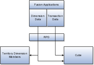
Dimension members are populated and synchronized in Oracle Business Intelligence Suite Enterprise Edition Plus either through the data warehouse, or without the use of data warehouse. You must repopulate dimension members when source data changes, such as changes in the product catalog and the addition of new customers.
When you do not use data warehouse, dimension and transaction data are populated directly from Fusion Applications into territory dimension members and the Oracle Essbase cube. The structure of the cube reflects the enabled dimensions in Territory Management and their members. The cube provides metrics information for defined territories.
This figure shows the population of the dimension members data and the Oracle Essbase cube using the Repository Project Design (RPD) view from Business Intelligence.
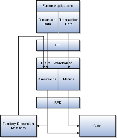
(On-Premise implementations only.) In the Data Warehouse option, the data warehouse Extract-Transform-Load (ETL) logic extracts transaction and dimension data from Oracle Fusion Applications into the data warehouse first. The data warehouse stores dimensions and metrics data. Metrics data is based on transaction information. Territory Management contains only a subset of the dimensions stored in data warehouse.
This figure shows the use of ETL to load data from Fusion Applications to the data warehouse, and RPD to provide data to the cube and to Territory Management. ETL also loads the settings for visible and invisible dimension members from Territory Management to the data warehouse.
Use ETL to load data to the data warehouse when:
There are changes in the dimension members sources (Fusion Application), so that the new structure of the dimensions is reflected in the data warehouse and consequently in Territory Management.
After changing visibility settings for dimension members.
Territory Management generates the cube based on the enabled dimensions and their members. In the case of the data warehouse option, Territory Management loads the cube with dimension members and metrics directly from the data warehouse. In the case of the non-data warehouse option, the application loads the cube from Fusion Applications. The cube provides metrics information for defined territories.
There are several aspects to enabling and populating dimension members, including setting profile options for certain dimensions.
Following is the sequence for populating dimensions for use in defining territories:
Set up source data for the dimensions you plan to use. This includes:
Master geography and territory geography zone hierarchies
Customers with a sell-to address and Named Sales Account selected
Product catalog
Customer sizes lookup
Classification codes for the Organization Type classification category
Industry classification category and codes
Customer classification categories and codes for auxiliary dimensions
Change profile options for industry classification category or the classification category for auxiliary dimensions 1, 2, or 3.
If you are using data warehouse, then run ETL to populate the data warehouse with the dimension members and transactional data.
In Territory Management, identify the dimension members you want visible in selection lists for defining territories. Refresh the members before making visibility selections.
If you are using data warehouse, then run ETL to populate the data warehouse with visibility settings.
Use the stage environment in Territory Management to enable dimensions. Execute the Stage action that synchronizes the Territory Management stage environment with the data source. You can start defining territories using newly enabled and populated dimensions after you promote the stage environment to production.
The sales administrator enables only the dimensions the organization requires for defining territories. The following examples illustrate the use of different dimensions to assign sales accounts, leads, and opportunities to the correct salespeople using defined territories.
For most of your sales activities, you want to assign salespeople by city and postal code.
You have a few key accounts that should belong to top salespeople. Use the account dimension to create territories for individual sales accounts.
You want to assign major sales accounts to Named accounts territories A named account territory can have child territories identified by other criteria, such as geography. You also have territories with the account type of Not Named that include no major named sales accounts in the hierarchy.
One product line is suitable only for organizations above a certain size. Use the customer size dimension to target only the larger customers for the product line.
You sell one type of service to telecommunications companies, another service to utilities, and a third service for insurance companies. You can create territories for each using the industry dimension.
You sell a product line that requires salespeople to have a high degree of technical knowledge. Create separate territories for this product line.
You delegate sales accounts that are small to partner sales organizations by geography.
A validation routine compares changes in the stage environment with active territories and identifies problems with active territories caused by the dimension members in the stage environment. Use the generated error correction proposal to correct active territories that require changes before the stage environment can move to production.
An Invalid icon appears next to every territory in the active territories list that the changes in the stage environment will make invalid. The error correction proposal owner needs to add the invalid territories to the error correction proposal and change definitions to correspond with the dimension member changes in the stage environment. For example, delete a newly disabled dimension from the territory. When the stage environment is promoted to production, the validation process is run again and if all is valid, the territories in the error correction proposal get activated.
The Stage Only process runs checks for errors, and the administrator can then analyze the environment and make any corrections before promoting it to an active environment, or deleting the stage environment.
The stage process synchronizes the dimensionsand metrics with the source and checks for any errors that occur if the current territory definitions were based on the stage data. If a change in enabled dimensions causes a currently active territory to become invalid, then the error must be corrected either by changing the enable selection or changing the territory definition before promoting the stage environment to production.
In a stage environment, the administrator changes dimension parameters and enables or disables dimensions and metrics , without affecting current territory management activities. The production environment provides enabled dimensions and metrics for ongoing territory definition activities.
Automatically staging and promoting the environment synchronizes the stage environment with the data source, runs validation checks, and if no errors, promotes (moves) the stage environment data to production.