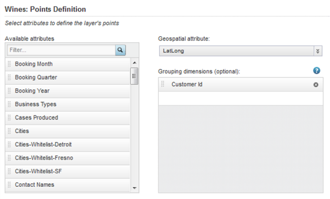
On the Points Definition tab for the map layer, you select the geocode attribute to use for the map points.
For an aggregated layer, you also select the group dimensions to use for the aggregation. For a heat map layer, you select the metric to use to determine the point colors.
To define the map points:
-
If you are creating an aggregated map layer, then you configure
the list of grouping dimensions to use for the aggregation.
-
To add a dimension to the list, drag a dimension from the
Available attributes list to the
Grouping dimensions list.
-
To add a dimension to the list, drag a dimension from the
Available attributes list to the
Grouping dimensions list.
-
For a heat map layer, you can select a metric to use for setting
the layer point and heat cloud colors.
For example, if the locations are stores, then the heat map layer colors could reflect the total sales at each store.
If you do not select a metric, then the heat map colors are based on the relative density of the points on the map. So if the locations are stores, then the heat map colors would change based on the number of stores in a given area.
Note: Heat maps without a metric require HTML5, and do not work on Internet Explorer 8. If you configure a heat map without a metric, then for end users using Internet Explorer 8, the map layer is disabled.To select the metric, click the Select Metric button. On the metric dialog, click the metric, then click Apply.
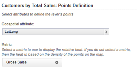
For predefined metrics or system metrics, the aggregation method is built in.
For other attributes, the default aggregation method is assigned. You can then use the drop-down list to select a different aggregation method.
To select a different metric, click the delete icon, then click Select Metric.
