Spatial AI Modeling Workflow
Learn about the Spatial AI modeling workflow for both supervised and unsupervised machine learning.
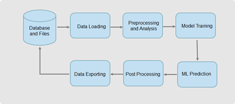
The following flowchart shows the typical workflow of Spatial AI modeling and analysis.
As seen in the preceding figure, the workflow comprises the following steps - data loading, preprocessing, training and evaluating ML models, predicting using the trained model, post-processing the results, and exporting the results back into database or files in other storage.
The workflow applies to both supervised (regression, classification, and anomaly detection) and unsupervised (clustering and regionalization) machine learning . However, in the latter case, the training and prediction actions are merged together into one step.
The workflow actions shown in the preceding figure are supported by the following components:
- Data Access: This component helps for reading from and writing
into one of the following data sources - Autonomous AI Database Serverless, OCI Object Storage, or local files. However, note that
the main storage system is the Autonomous AI Database Serverless database. A single proxy spatial data frame is used for both
data loading and data exporting.
See Access Spatial Data for more information.
- Preprocessing: This component prepares, processes, and augments
source data. It includes filling missing values, scaling data, engineering new
features, and splitting the source dataset into training dataset, validation
dataset, and test dataset.
See Preprocess Spatial Data for more information.
- Spatial Analysis: This component provides basic spatial
analytics. These are then used together with or to facilitate machine learning
modeling to achieve better results or gain better insights.
See Perform Spatial Analysis for more information.
- AI Machine Learning Algorithms: This component is at the core of
Spatial AI and provides algorithms and techniques for descriptive and predictive
analysis.
Each algorithm provides methods that allows you to create or train models and make predictions.
- Regression, classification, and anomaly detection
algorithms: These are supervised learning algorithms where each
algorithm has a fit method for training, a score method for evaluation, and
a predict method for prediction.
See Apply Spatial Regression, Apply Spatial Classification, and Apply Spatial Anomaly Detection for more information.
- Clustering and regionalization algorithms: These are
unsupervised learning algorithms where each algorithm has a fit method for
both training and clustering.
See Apply Spatial Clustering for more information.
In addition to training and applying each model individually, this component also provides adaptive spatial regression. This tool enables you to automatically search and evaluate different regression algorithms and find out the best algorithm for a specific application.
- Regression, classification, and anomaly detection
algorithms: These are supervised learning algorithms where each
algorithm has a fit method for training, a score method for evaluation, and
a predict method for prediction.
- Post-processing: This component generally includes cleaning the
results, removing redundancy, georeferencing spatial data, converting data formats,
and generating and storing useful spatial layers.
As the Spatial AI machine learning is applied only with spatial vector data, the results are relatively simple without much need of post-processing. The resulting data can be directly stored back in the database using the data access component. You can then further process the data through Oracle Spatial functionalities.
See Run Post-Processing Tasks for more information.
- Spatial pipeline: The pipeline provides the capabilities to
organize and simplify spatial machine learning workflow. The spatial pipeline
extends the existing
scikit-learnpipeline to take spatial information such as geometry data and spatial weights.See Work with Spatial Pipeline for more information.
