1.4 Geometry Types
A geometry is an ordered sequence of vertices that are connected by straight line segments or circular arcs.
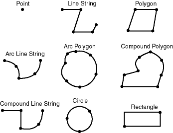
The semantics of the geometry are determined by its type. Spatial supports several primitive types, and geometries composed of collections of these types, including two-dimensional:
-
Points and point clusters
-
Line strings
-
n-point polygons
-
Arc line strings (All arcs are generated as circular arcs.)
-
Arc polygons
-
Compound polygons
-
Compound line strings
-
Circles
-
Optimized rectangles
Two-dimensional points are elements composed of two ordinates, X and Y, often corresponding to longitude and latitude. Line strings are composed of one or more pairs of points that define line segments. Polygons are composed of connected line strings that form a closed ring, and the area of the polygon is implied. For example, a point might represent a building location, a line string might represent a road or flight path, and a polygon might represent a state, city, zoning district, or city block.
Self-crossing polygons are not supported, although self-crossing line strings are supported. If a line string crosses itself, it does not become a polygon. A self-crossing line string does not have any implied area.
The following figure illustrates the geometric types.
Spatial also supports the storage and indexing of three-dimensional and four-dimensional geometric types, where three or four coordinates are used to define each vertex of the object being defined. For information about support for three-dimensional geometries, see Three-Dimensional Spatial Objects.
Parent topic: Spatial Concepts
