4.2.3 Displaying a Spatial Studio GeoRaster Dataset as Image Tiles
Similar to how the geometry dataset from Spatial Studio can be displayed
in a standalone MapLibre map, GeoRaster datasets from Spatial Studio can also be
easily added to your MapLibre map. As mentioned in the earlier sections, the REST
endpoint for returning the image tiles of a GeoRaster dataset requires the image
column’s id as part of the REST endpoint URL. Unlike easily finding
out the id of a dataset from its properties dialog, in this case,
you must use a cURL command to obtain the image column
id. For example:
curl -k "https://localhost:4040/spatialstudio/oauth/v1/datasets/<DATASET_ID>/columns?datasetFields=georasterColumns&columnFields=id,name" \
 --header "Authorization: Bearer <MY_TOKEN>”
The preceding REST endpoint returns the metadata of all the columns in
the specified dataset. The query parameters, datasetFields and
columnFields are used to filter the response so that only the
fields matching the given names are returned to the client. In this case, the
requirement is to obtain the georasterColumns field, which
indicates the name of the dataset’s GeoRaster image columns (that store raster image
data). For the individual columns in that dataset, only the name
and id are required.
The request returns a similar response:
{
  "georasterColumns": [
    "IMAGE"
  ],
  "columnDetails": [
    {
      "id": "09b60f1da4c6808d753c57393c6f899f",
      "name": "IMAGE_ID"
    },
    {
      "id": "7223184218fc39ac149c91155a9f9242",
      "name": "MIN_X_RES$"
    },
    {
      "id": "e56426442075b028018175740b64449d",
      "name": "IMAGE"
    },
    {
      "id": "c254f40e6ea6f14f4899c8801b485b24",
      "name": "MAX_X_RES$"
    },
    {
      "id": "5c4d7c6963f7234adc97fafc52c0c04c",
      "name": "DESCRIPTION"
    }
  ]
}
In the preceding response, the id of the image column
is e56426442075b028018175740b64449d, which is then used in
the following example code to display a Spatial Studio GeoRaster dataset on a
standalone MapLibre application.
<!DOCTYPE html>
<html lang="en">
<head>
    <meta charset="utf-8">
    <title>Display GeoRaster imagery from Spatial Studio</title>
    <meta name="viewport" content="initial-scale=1,maximum-scale=1,user-scalable=no">
    <script src="https://unpkg.com/maplibre-gl@2.1.9/dist/maplibre-gl.js"></script>
    <link href="https://unpkg.com/maplibre-gl@2.1.9/dist/maplibre-gl.css" rel="stylesheet">
    <style>
        body { margin: 0; padding: 0; }

        .container {
            position: absolute;
            width: 100%;
            height: 100%;
        }
        .control {
            background-color: #a9cce3 ;
            width: 100%;
            height: 100px;
            margin: 5px auto;
        }
        .map_container {
            position: absolute;
            top: 100px;
            bottom: 0;
            width: 100%;
            margin: 5px auto;
        }
    </style>
</head>
<body>

<div class="container">
    <div class="control">
        <form>
          <fieldset>
                <legend>GeoRaster display settings</legend>
                <p>
                    <input type="checkbox" name="nodata_flag" id="nodata_flag">
                    <label for="nodata_flag">Show NODATA values as transparent</label>
                </p>
          </fieldset>
        </form>
    </div>

    <div class="map_container" id="map"></div>
</div>


<script>
    // basic information about the remote Spatial Studio instance that is serving the GeoRaster images.
    const spatialStudio = {
        // the base URL for accessing Spatial Studio dataset's GeoRaster image tiles using an access token
        baseUrl : 'https://localhost:4040/spatialstudio/oauth/v1',
        rasterTileEndpoint: '/rt/e56426442075b028018175740b64449d/{z}/{x}/{y}.png',
        // a stream-only access token issued by Spatial Studio
        accessToken: 'eyJ0eXAiOiJzZ3R...qOdHV3koQsYF_MkKQ'
    };

    const sourceId = 'spatial-studio-raster-tiles1';

    const map = new maplibregl.Map({
        container: 'map',
        // Gets the OpenStreetMap basemap from maptiler.com. You must change to use your own maptiler API key and agree to their terms of usage.
        style: 'https://api.maptiler.com/maps/openstreetmap/style.json?key=YOUR_KEY,
        zoom: 6,
        center: [-90.241936, 33.911399],

        //This option sets a Spatial Studio access token when requesting the image tiles of a GeoRaster dataset.
        transformRequest: (url, resourceType) => {
            if (resourceType === 'Tile'&& url.startsWith(spatialStudio.baseUrl)){
                return {
                    url: url,
                    headers: {'Authorization': 'Bearer ' + spatialStudio.accessToken}
                }
            }
        }
    });

    // Controls the visual appearances of the GeoRaster images generated by Studio. This is appended to the Studio tile request URLs.
    let geoRasterVisualProperties = {"reprojection":{"mode":"NN","medianfilter":false},"transpnodata":false,"virtualmosaic":{"resolfilter":true,"nodata":true,"fillgap":true,"commonpointrule":"HIGH"},"bands":{"red":1,"green":2,"blue":3,"alpha":-1}};

    map.on('load', function () {
        // Adds the image tiles for the Spatial Studio GeoRaster dataset with the specified column id (not dataset id) "e56426442075b028018175740b64449d" to
        // the map.
        //
        map.addSource(sourceId, {
            'type': 'raster',
            'tiles' : [
                   spatialStudio.baseUrl + spatialStudio.rasterTileEndpoint + '?visualProperties=' + JSON.stringify(geoRasterVisualProperties)
                ],
            'minzoom': 5,
            'maxzoom': 20,
            'tileSize' : 256,
            // this tells MapLibre API that the dataset only has GeoRaster images within this bounding box
            'bounds': [-90.4895407500805, 32.3190270753724, -89.9586424931126, 35.2761555998833]
        });

        // Defines and adds a layer from the above Map source.
        map.addLayer(
            {
                'id': 'my_georaser_layer',
                'type': 'raster',
                'source': sourceId,
                'paint':  {
                    'raster-opacity': 0.72,
                    'raster-hue-rotate': 0,
                    'raster-brightness-min': 0,
                    'raster-brightness-max': 1,
                    'raster-saturation': 0,
                    'raster-contrast': 0,
                    'raster-fade-duration': 300
                }
            }
        );
    });

    map.addControl(new maplibregl.NavigationControl());

    // Toggles the display of GeoRaster NODATA values between transparent or not.
    // This is done by changing the visual properties object's "nodata" field,
    // then reloading the GeoRaster images from Spatial Studio using the new properties.
    function toggleNODATA(flag) {
        if (geoRasterVisualProperties.transpnodata === flag) {
            return; // do nothing since we are already using the input value
        }

        geoRasterVisualProperties.transpnodata = flag;

        // update map source so that future tile requests will generate tiles with the new visual properties.
        const sourceObj = map.getSource(sourceId);
        const newTileUrl = spatialStudio.baseUrl + spatialStudio.rasterTileEndpoint + '?visualProperties=' + JSON.stringify(geoRasterVisualProperties);

        sourceObj.tiles = [newTileUrl];
        // Remove all the existing, cached tiles of the GeoRaster source
        map.style.sourceCaches[sourceId].clearTiles();
        // Reloads the GeoRaster image tiles for the current viewport (map.transform -> viewport)
        map.style.sourceCaches[sourceId].update(map.transform);
        // Force a map repaint
        map.triggerRepaint();
    }

    // add callback to the nodata checkbox
    const nodataCheckbox = document.querySelector('#nodata_flag');

    nodataCheckbox.addEventListener('change', () => {
        if(nodataCheckbox.checked){
            toggleNODATA(true);
        } else {
            toggleNODATA(false);
        }
    });

</script>

</body>
</html>
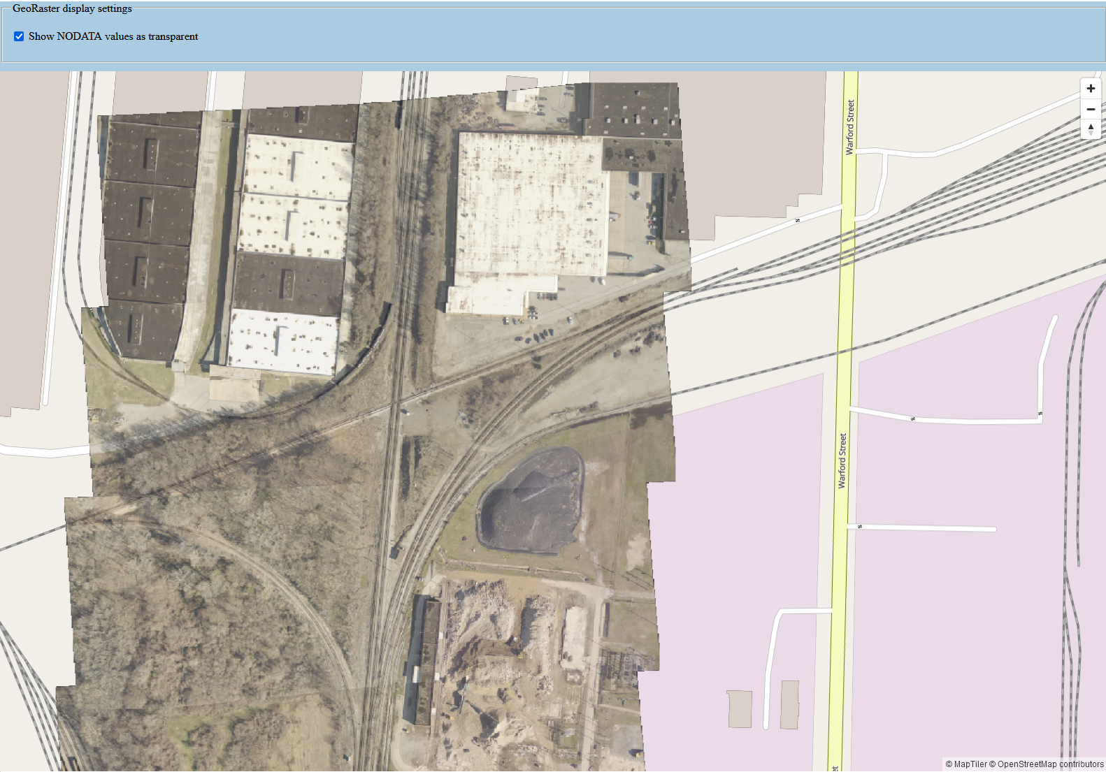
The following shows the output map with the GeoRaster (high resolution images) overlaid on top of the OpenStreetMap. When you toggle the Show NODATA values as transparent, the GeoRaster images will display its NODATA area either as black or transparent pixels.
Figure 4-2 Displaying a GeoRaster Dataset in the MapLibre Application

Description of "Figure 4-2 Displaying a GeoRaster Dataset in the MapLibre Application"
Note the following on the preceding GeoRaster image:
- The overall pattern remains similar to how geometry datasets are displayed. You only need to change the Spatial Studio REST endpoint and how the MapLibre Source and Layer objects are defined.
- You can fine-tune the generated image tiles by supplying a visual properties payload as part of the image tile request.
- Spatial Studio takes care of all the backend processes such as querying the GeoRaster table or virtual mosaic based on the browser’s image tile requests, applying the specified visual properties, and sending the result images back to the browser.
Parent topic: Accessing Spatial Studio REST API Programmatically