General Settings
This section covers all global settings for configuring Vision.
General Settings
The following path shows how to navigate in the UI:
- General -> Settings
The following figure shows the table of general settings.
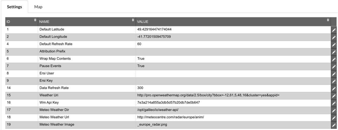
Description of illustration general-settings-view.png
This tab covers general settings:
-
Default Latitude: This is the default latitude set on the map at start-up and when you click the Home button.
-
Default Longitude: This is the default longitude set on the map at start-up and when you click the Home button.
-
Default Refresh rate: The delay in seconds between calls to refresh events in Vision. Defaults to 60 seconds if you set anything lower than that number.
-
Attribution Prefix: The prefix for the information shown in the attribution box for the tile layers.
-
Wrap map contents: Used within leaflet to set whether the map jumps when panning over the date line, set to false where customer is near or on the date line. By default this is set to true.
-
Pause Events: Boolean to enable or disable pausing events when the popup is opened or the search is activated.
-
Ersi User: Username for user with permissions to get ERSI map data.
-
Ersi Key: Key for access to the ERSI map data.
-
Data Refresh rate: The delay in seconds between calls to refresh the data in Vision. Defaults to 300 seconds if you set anything lower than that number.
-
Weather Uri: URL used to gather data from Open Weather Maps weather station data. In the URL the bbox value is an area defined by two longitudes and two latitudes in this format: min Longitude , min Latitude , max Longitude , max Latitude.
-
Wm Api Key: Key for access to the Open Weather Maps API.
-
Meteo Weather Dir: Folder where image from Meteo is stored.
-
Meteo Weather Uri: Start of the URL to get the Meteo Weather Image from.
-
Meteo Weather Image: End of the URL to get the Meteo Weather Image from.
Columns that can be edited:
- Value: The data value you want to enter for that row, this is row specific. There is validation in place for the input so that only valid values can be saved.
Map
The following path shows how to navigate in the UI:
- General -> Map
The following figure shows the map defaults configuration form. It allows you to set default latitude, default longitude, default zoom and default base map.
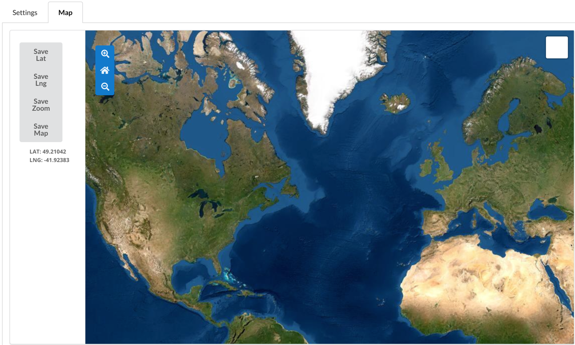
Description of illustration map-settings-view.png
This tab covers changing the defaults of the map in the main view of Vision. There are 4 buttons used to save the various configuration values for the map. The buttons are:
-
Save Lat: This saves the Latitude of the current centre point of the displayed map. The value can be seen in the text box below the buttons.
-
Save Lng: This saves the Longitude of the current centre point of the displayed map. The value can be seen in the text box below the buttons.
-
Save Zoom: This saves the current zoom level of the displayed map.
-
Save Map: The saves the current basemap chosen in the controller in the top right of the displayed map.