Tasks Feature Class and Feature Layer
The Tasks feature class represents the fields required to complete a work order or work request in ESRI ArcGIS Field Maps. The fields correspond to similar fields on the work order and work request form in the “New Work” screens in the Oracle Field Service Accelerator package.
Tasks feature class has a spatial representation of a point.
Below is the Tasks fields schema after the Tasks Workspace document is loaded into ArcGIS Pro.
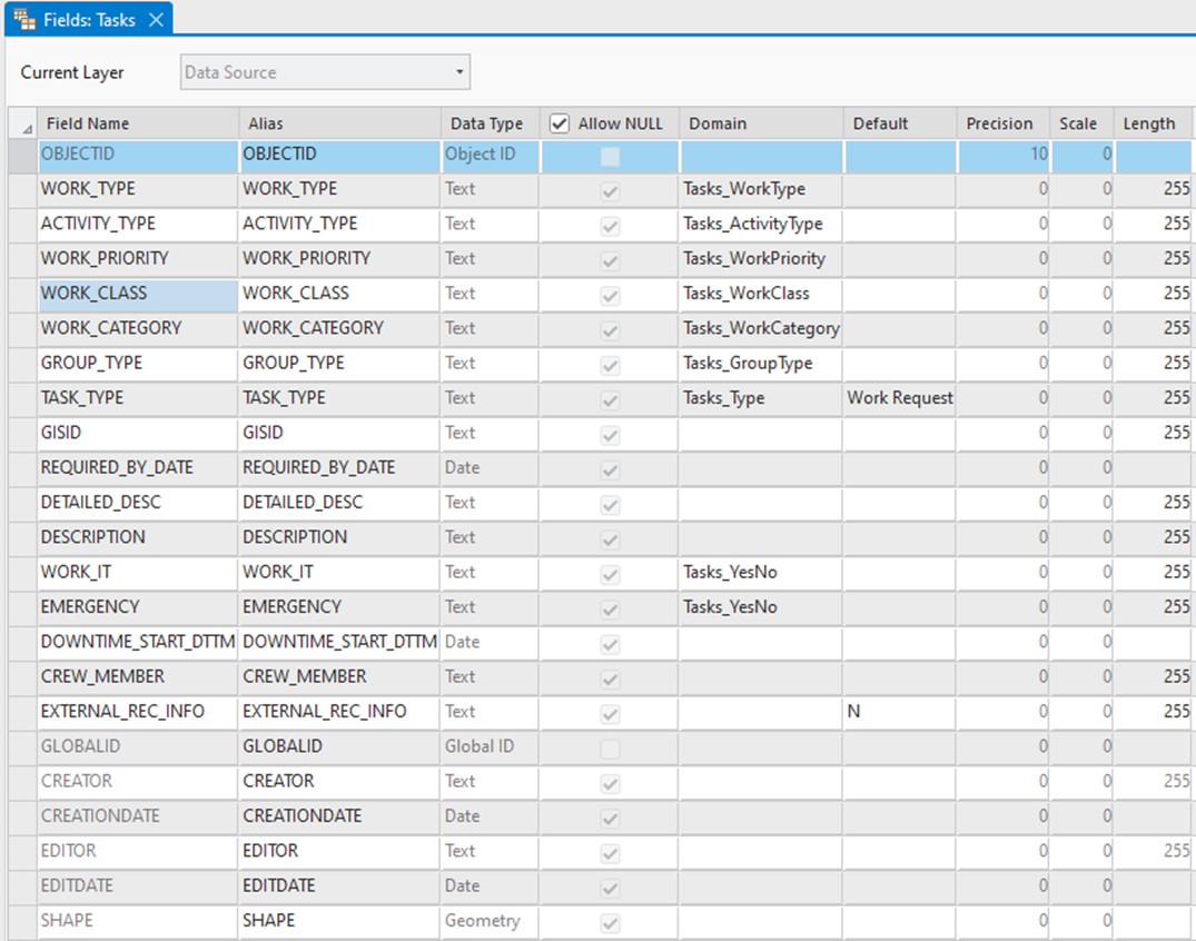
The table below shows the Tasks feature class schema along with associated domain values:
Field Name | Description | Data Type | Domain Values | Visibility in Work Order /Work Request |
|---|---|---|---|---|
OBJECTID | Object Id | Object ID | ||
WORK_TYPE | WAM Work Types | Text | Tasks_WorkType | |
ACTIVITY_TYPE | WAM Activity Types | Text | Tasks_ActivityType | |
WORK_PRIORITY | WAM Priority Types | Text | Tasks_WorkPriority | |
WORK_CLASS | WAM Work Class | Text | Tasks_WorkClass | |
WORK_CATEGORY | WAM Work Category | Text | Tasks_WorkCategory | |
GROUP_TYPE | WAM Group Type | Text | Tasks_GroupType | |
TASK_TYPE | Form type to enter. Possible values are ‘Work Order’ or ‘Work Request’. Corresponding values are visible or hidden based on the value selected. Default value: Work Request | Text | Tasks_Type | Work Order/Work Request |
GISID | Global ID of the asset for which work order or work request is created. | Text | ||
REQUIRED_BY_ DATE | Required by date of work order or work request | Date | ||
DETAILED_DESC | Detailed description | Text | ||
DESCRIPTION | Description | Text | ||
WORK_IT | Indicates if the work order is assigned to the fieldworker creating it. | Text | Tasks_YesNo | Work Order |
EMERGENCY | If it is an emergency task | Text | Tasks_YesNo | Work Order |
DOWNTIME_START_DTTM | Downtime start date and time | Date | ||
CREW_MEMBER | Enterprise portal user ID of the user submitting the tasks form | Text | ||
EXTERNAL_REC_ INFO | This field holds the OFS Activity ID for work order or OFS service request number for work request. Default value: N | |||
GLOBALID | Global ID of Tasks record | Global ID | ||
CREATOR | Editor tracking field. Stores the username of the who created the feature record. | Text | ||
CREATIONDATE | Editor tracking field. Creation date of the feature record. | Date | ||
EDITOR | Editor tracking field. Stores the username of the who edited the feature record. | Text | ||
EDITDATE | Editor tracking field. Edit date of the feature record. | Date | ||
SHAPE | Geometry of the feature, which is a point. | Geometry |
Attribute Domains
Each domain values correspond to the respective drop-down lists on the work order and work request form configured on the Task feature class.
The domain values which are marked to be updated by “Updated by csv files” can be updated by running the “OU ArcGIS OFS Admin Files Create” Oracle Integration Cloud work flow.
Domain Value Name | Sample Values | Updated by csv files |
|---|---|---|
Tasks_WorkType | Code: W1PM Description: Preventive Maintenance | Yes |
Tasks_ActivityType | Code: WD-LeakRepair Description: Activity - Gas Leak Repair | Yes |
Tasks_WorkPriority | Code: 01 Description: 01 | Yes |
Tasks_WorkClass | Code: WDPL Description: Planned | Yes |
Tasks_WorkCategory | Code: WDFL Description: Failure | Yes |
Tasks_GroupType | Code: WACS Description: WACS | No |
Tasks_Type | Code: WR Description: Work Request | No |
Tasks_YesNo | Code: N Description: No | No |
For more information on attribute domains, refer to https://pro.arcgis.com/en/pro-app/3.1/help/data/geodatabases/overview/an-overview-of-attribute-domains.htm
Contingent Values
A value in the Work Category domain is dependent on the value selected in the Work Class domain values. All the allowed values of work category for a particular value of work class is defined through Contingent values. These Contingent values are defined through FieldGroup WorkClassWorkCategory. The FieldGroup and ContingentValues csv files from a particular Oracle Utilities Work and Asset Management/ESRI ArcGIS Field Maps environment are generated by running the “OU ArcGIS OFS Admin Files Create” Oracle Integration Cloud work flow.
For more information on contingent values, refer to: https://pro.arcgis.com/en/pro-app/3.1/help/data/geodatabases/overview/contingent-values.htm