Activities Feature Class and Feature Layer
Activities Feature class represents the Oracle Field Service activities to be shown on maps. Fields in this feature class represent different data points of the Oracle Field Service activities that are created corresponding to the activities created from Oracle Utilities Work and Asset Cloud Service as part of the integration.
Activities feature class has a spatial representation of a point. Below is the schema of the Activities Feature class.
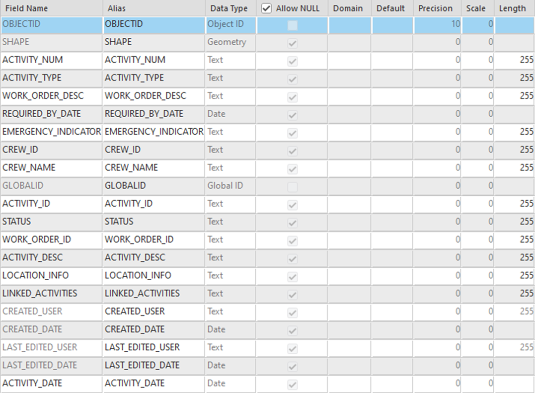
The following table represents the Activities schema:
Field Name | Description | Data Type |
|---|---|---|
OBJECTID | Object Id | Object ID |
SHAPE | Shape (Geometry) | Geometry |
ACTIVITY_NUM | WACS Activity number | Text |
ACTIVITY_TYPE | WACS Activity type | Text |
WORK_ORDER_DESC | Work order description | Text |
REQUIRED_BY_DATE | Required by date by which the activity must be completed | Date |
EMERGENCY_INDICATOR | If this activity is a emergency or not | Text |
CREW_ID | OFS Crew ID | Text |
CREW_NAME | OFS Crew name | Text |
GLOBAL_ID | Global Id | Global Id |
ACTIVITY_ID | OFS Activity ID | Text |
STATUS | OFS status of the activity | Text |
WORK_ORDER_ID | When integrated with WACS as part of WACS-OFS integration, this field represents the WAM work order ID. | Text |
ACTIVITY_DESC | Activity description | Text |
LOCATION_INFO | Activity location information | Text |
LINKED_ACTIVITIES | Linked activities. This field is not used currently. | Text |
ACTIVITY_DATE | Date the OFS activity was assigned. | Date |
CREATED_USER | ArcGIS editor field. It represents the ArcGIS user that created this feature record. It will be empty when created through OIC flow. | Text |
CREATED_DATE | ArcGIS editor field. It represents the date when the feature record was created in feature class. | Date |
LAST_EDITED_USER | ArcGIS editor field. It represents the ArcGIS user that updates this feature record. It will be empty when updated through the OIC flow. | Text |
LAST_EDITED_DATE | ArcGIS editor field. It represents the date when the feature record was updated in the feature class. | Date |