Release 9.0.1
Part Number A88805-01
Home |
Book List |
Contents |
Index | Master Index | Feedback |
| Oracle Spatial User's Guide and Reference Release 9.0.1 Part Number A88805-01 |
|
![]()
![]()
This chapter describes how to load spatial data into a database, including storing the data in a table with a column of type SDO_GEOMETRY. After you have loaded spatial data, you can create a spatial index for it and perform queries on it, as described in Chapter 4.
The process of loading data can be classified into two categories:
This process is used to load large volumes of data into the database and uses the SQL*Loader utility to load the data.
This process is used to insert relatively small amounts of data into the database using the INSERT statement in SQL.
Bulk loading can import large amounts of ASCII data into an Oracle database. Bulk loading is accomplished with the SQL*Loader utility. (For information about SQL*Loader, see Oracle9i Database Utilities.)
Example 3-1 is the SQL*Loader control file for loading four geometries. When this control file is used with SQL*Loader, it loads the same cola market geometries that are inserted using SQL statements in Example 2-1 in Section 2.1.
LOAD DATA
INFILE *
TRUNCATE
CONTINUEIF NEXT(1:1) = '#'
INTO TABLE COLA_MARKETS
FIELDS TERMINATED BY '|'
TRAILING NULLCOLS (
mkt_id INTEGER EXTERNAL,
name CHAR,
shape COLUMN OBJECT
(
SDO_GTYPE INTEGER EXTERNAL,
SDO_ELEM_INFO VARRAY TERMINATED BY '|/'
(elements FLOAT EXTERNAL),
SDO_ORDINATES VARRAY TERMINATED BY '|/'
(ordinates FLOAT EXTERNAL)
)
)
begindata
 1|cola_a|
#2003|1|1003|3|/
#1|1|5|7|/
 2|cola_b|
#2003|1|1003|1|/
#5|1|8|1|8|6|5|7|5|1|/
 3|cola_c|
#2003|1|1003|1|/
#3|3|6|3|6|5|4|5|3|3|/
 4|cola_d|
#2003|1|1003|4|/
#8|7|10|9|8|11|/
Notes on Example 3-1:
EXTERNAL keyword in the definition mkt_id INTEGER EXTERNAL means that each value to be inserted into the MKT_ID column (1, 2, 3, and 4 in this example) is an integer in human-readable form, not binary format.
begindata, each MKT_ID value is preceded by one space, because the CONTINUEIF NEXT(1:1) = '#' specification causes the first position of each data line to be ignored unless it is the asterisk (#) continuation character.
Example 3-2 assumes that a table named POLY_4PT was created as follows:
CREATE TABLE POLY_4PT (GID     VARCHAR2(32),
                       GEOMETRY  MDSYS.SDO_GEOMETRY);
Assume that the ASCII data consists of a file with delimited columns and separate rows fixed by the limits of the table with the following format:
geometry rows: GID, GEOMETRY
The coordinates in the GEOMETRY column represent polygons. Example 3-2 shows the control file for loading the data.
LOAD DATA
 INFILE *
 TRUNCATE
 CONTINUEIF NEXT(1:1) = '#'
 INTO TABLE POLY_4PT
 FIELDS TERMINATED BY '|'
 TRAILING NULLCOLS (
  GID  INTEGER EXTERNAL,
  GEOM COLUMN OBJECT
   (
     SDO_GTYPE       INTEGER EXTERNAL,
     SDO_ELEM_INFO   VARRAY TERMINATED BY '|/'
       (elements     FLOAT EXTERNAL),
     SDO_ORDINATES   VARRAY TERMINATED BY '|/'
       (ordinates    FLOAT EXTERNAL)
   )
)
begindata
 1|2003|1|1003|1|/
#-122.4215|37.7862|-122.422|37.7869|-122.421|37.789|-122.42|37.7866|
#-122.4215|37.7862|/
 2|2003|1|1003|1|/
#-122.4019|37.8052|-122.4027|37.8055|-122.4031|37.806|-122.4012|37.8052|
#-122.4019|37.8052|/
 3|2003|1|1003|1|/
#-122.426|37.803|-122.4242|37.8053|-122.42355|37.8044|-122.4235|37.8025|
#-122.426|37.803|/
Example 3-3 shows a control file for loading a table with point data.
LOAD DATA
 INFILE *
 TRUNCATE
 CONTINUEIF NEXT(1:1) = '#'
 INTO TABLE POINT
 FIELDS TERMINATED BY '|'
 TRAILING NULLCOLS (
  GID      INTEGER EXTERNAL,
  GEOMETRY COLUMN OBJECT
   (
     SDO_GTYPE       INTEGER EXTERNAL,
     SDO_POINT COLUMN OBJECT
       (X            FLOAT EXTERNAL,
        Y            FLOAT EXTERNAL)
   )
)

BEGINDATA
 1| 2001| -122.4215| 37.7862|
 2| 2001| -122.4019| 37.8052|
 3| 2001| -122.426| 37.803|
 4| 2001| -122.4171| 37.8034|
 5| 2001| -122.416151| 37.8027228|
Oracle Spatial uses standard Oracle9i tables that can be accessed or loaded with standard SQL syntax. This section contains examples of transactional inserts into columns of type SDO_GEOMETRY. Note that the INSERT statement in Oracle SQL has a limit of 999 arguments. Therefore, you cannot create a variable-length array of more than 999 elements using the SDO_GEOMETRY constructor inside a transactional INSERT statement; however, you can insert a geometry using a host variable, and the host variable can be built using the SDO_GEOMETRY constructor with more than 999 values in the SDO_ORDINATE_ARRAY specification. (The host variable is an OCI, PL/SQL, or Java program variable.)
To perform transactional insertions of geometries, you can create a procedure to insert a geometry, and then invoke that procedure on each geometry to be inserted. Example 3-4 creates a procedure to perform the insert operation.
CREATE OR REPLACE PROCEDURE
        INSERT_GEOM(GEOM MDSYS.SDO_GEOMETRY)
IS

BEGIN
  INSERT INTO TEST_1 VALUES (GEOM);
  COMMIT;
END;
/
Using the procedure created in Example 3-4, you can insert data by using a PL/SQL block, such as the one in Example 3-5, which loads a geometry into the variable named geom and then invokes the INSERT_GEOM procedure to insert that geometry.
DECLARE
geom mdsys.sdo_geometry :=
  mdsys.sdo_geometry (2003, null, null,
          mdsys.sdo_elem_info_array (1,1003,3),
          mdsys.sdo_ordinate_array (-109,37,-102,40));
BEGIN
  INSERT_GEOM(geom);
  COMMIT;
END;
/
The geometry to be stored can be a polygon with a hole, as shown in Figure 3-1.
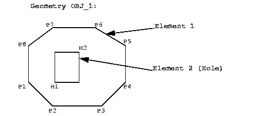
The coordinate values for Element 1 and Element 2 (the hole), shown in Figure 3-1, are:
Element 1= [P1(6,15), P2(10,10), P3(20,10), P4(25,15), P5(25,35), P6(19,40),
    P7(11,40), P8(6,25), P1(6,15)]
Element 2= [H1(12,15),  H2(15,24)]
The following example assumes that a table named PARKS was created as follows:
CREATE TABLE PARKS (NAME VARCHAR2(32),
                    SHAPE MDSYS.SDO_GEOMETRY);
The SQL statement for inserting the data for geometry OBJ_1 is:
INSERT INTO PARKS
  VALUES ('OBJ_1', MDSYS.SDO_GEOMETRY(2003, NULL,NULL,
                     MDSYS.SDO_ELEM_INFO_ARRAY(1,1003,1, 19,2003,3),
                     MDSYS.SDO_ORDINATE_ARRAY(6,15, 10,10, 20,10, 25,15, 25,35,
                         19,40, 11,40, 6,25, 6,15, 12,15, 15,24)));
The SDO_GEOMETRY object type takes values and constructors for its attributes SDO_GTYPE, SDO_ELEM_INFO, and SDO_ORDINATES. The SDO_GTYPE is 2003, and the SDO_ELEM_INFO has 2 triplet values because there are 2 elements. Element 1 starts at offset 1, is of ETYPE 1003, and its interpretation value is 1 because the points are connected by straight line segments. Element 2 starts at offset 19, is of ETYPE 2003, and has an interpretation value of 3 (a rectangle). The SDO_ORDINATES varying length array has 22 values with SDO_ORDINATES(1...18) describing element 1 and SDO_ORDINATES(19...22) describing element 2.
Assume that two dimensions are named X and Y, their bounds are 0 to 100, and the tolerance for both dimensions is 0.005. The SQL statement for loading the
USER_SDO_GEOM_METADATA metadata view is:
INSERT INTO USER_SDO_GEOM_METADATA
  VALUES ('PARKS', 'SHAPE',
          MDSYS.SDO_DIM_ARRAY(MDSYS.SDO_DIM_ELEMENT('X', 0, 100, 0.005),
                 MDSYS.SDO_DIM_ELEMENT('Y', 0, 100, 0.005)),
          NULL);
A compound line string is a connected sequence of straight line segments and circular arcs. Figure 3-2 is an example of a compound line string.
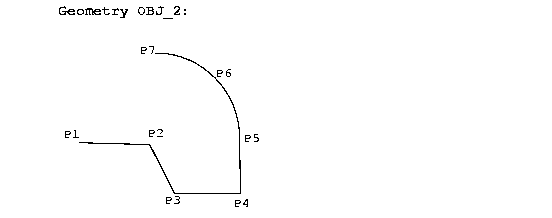
In Figure 3-2, the coordinate values for points P1..P7 that describe the line string OBJ_2 are:
OBJ_2 = [P1(15,10), P2(25,10), P3(30,5), P4(38,5), P5(38,10),

          P6(35,15), P7(25,20)]
The SQL statement for inserting this compound line string in a feature table defined as ROADS(GID Varchar2(32), Shape MDSYS.SDO_GEOMETRY) is:
INSERT INTO ROADS VALUES ('OBJ_2', MDSYS.SDO_GEOMETRY(2002, NULL, NULL,
   MDSYS.SDO_ELEM_INFO_ARRAY(1,4,2, 1,2,1, 9,2,2),
   MDSYS.SDO_ORDINATE_ARRAY(15,10, 25,10, 30,5, 38,5, 38,10, 35,15, 25,20)));
The SDO_GEOMETRY object type takes values and constructors for its attributes SDO_GTYPE, SDO_ELEM_INFO, and SDO_ORDINATES. The SDO_GTYPE is 2002, and the SDO_ELEM_INFO_ARRAY has 9 values because there are 2 subelements for the compound line string. The first subelement starts at offset 1, is of SDO_ETYPE 2, and its interpretation value is 1 because the points are connected by straight line segments. Similarly, subelement 2 has a starting offset of 9. That is, the first ordinate value is SDO_ORDINATES(9), is of SDO_ETYPE 2, and has an interpretation value of 2 because the points describe a circular arc. The SDO_ORDINATES_ARRAY varying length array has 14 values, with SDO_ORDINATES(1..10) describing subelement 1, and SDO_ORDINATES(9..14) describing subelement 2.
Assume that two dimensions are named X and Y, their bounds are 0 to 100, and tolerance for both dimensions is 0.005. The SQL statement to insert the metadata into the USER_SDO_GEOM_METADATA view is:
INSERT INTO USER_SDO_GEOM_METADATA VALUES ('ROADS', 'SHAPE',
  MDSYS.SDO_DIM_ARRAY(MDSYS.SDO_DIM_ELEMENT('X', 0, 100, 0.005),
                      MDSYS.SDO_DIM_ELEMENT('Y', 0, 100, 0.005)),
  NULL);
A compound polygon's boundary is a connected sequence of straight line segments and circular arcs, whose first point is equal to its last point. Figure 3-3 is an example of a compound polygon.
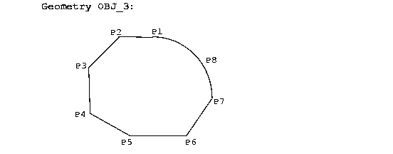
In Figure 3-3, the coordinate values for points P1 to P8 that describe the polygon OBJ_3 are:
OBJ_3 = [P1(20,30), P2(11,30), P3(7,22), P4(7,15), P5(11,10), P6(21,10),

   P7(27,30), P8(25,27), P1(20,30)]
The following example assumes that a table named PARKS was created as follows:
CREATE TABLE PARKS (GID VARCHAR2(32), SHAPE MSSYS.SDO_GEOMETRY);
The SQL statement for inserting this compound polygon is:
INSERT INTO PARKS VALUES ('OBJ_3', MDSYS.SDO_GEOMETRY(2003, NULL,NULL,
  MDSYS.SDO_ELEM_INFO_ARRAY(1,1005,2, 1,2,1, 13,2,2),
  MDSYS.SDO_ORDINATE_ARRAY(20,30, 11,30, 7,22, 7,15, 11,10, 21,10, 27,30,
    25,27, 20,30)));
The SDO_GEOMETRY object type takes values and constructors for its attributes SDO_GTYPE, SDO_ELEM_INFO, and SDO_ORDINATES. The SDO_GTYPE is 2003, the SDO_ELEM_INFO has 3 triplet values. The first triplet (1,1005,2) identifies the element as a compound polygon (ETYPE 1005) with two subelements. The first subelement starts at offset 1, is of ETYPE 2, and its interpretation value is 1 because the points are connected by straight line segments. Subelement 2 has a starting offset of 13, is of ETYPE 2, and has an interpretation value of 2 because the points describe a circular arc. The SDO_ORDINATES varying length array has 18 values, with SDO_ORDINATES(1...14) describing subelement 1, and SDO_ORDINATES(13...18) describing subelement 2.
This example assumes the PARKS table was created as follows:
CREATE TABLE PARKS (GID VARCHAR2(32), SHAPE MSSYS.SDO_GEOMETRY);
Assume that two dimensions are named X and Y, their bounds are 0 to 100, and tolerance for both dimensions is 0.005. The SQL statement to insert the metadata into the USER_SDO_GEOM_METADATA view is:
INSERT INTO USER_SDO_GEOM_METADATA VALUES ('PARKS', 'SHAPE',
  MDSYS.SDO_DIM_ARRAY(MDSYS.SDO_DIM_ELEMENT('X', 0, 100, 0.005),
                      MDSYS.SDO_DIM_ELEMENT('Y', 0, 100, 0.005)),
  NULL);
A compound polygon's boundary is a connected sequence of straight line segments and circular arcs. Figure 3-4 is an example of a geometry that contains a compound polygon with a hole (or void).
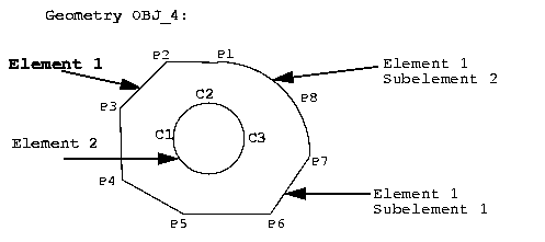
In Figure 3-4, the coordinate values for points P1 to P8 (Element 1) and C1 to C3 (Element 2) that describe the geometry OBJ_4 are:
Element 1 = [P1(20,30), P2(11,30), P3(7,22), P4(7,15), P5(11,10), P6(21,10),
             P7(27,30), P8(25,27), P1(20,30)]
Element 2 = [C1(10,17), C2(15,22), C3(20,17)]
The following example assumes that a table named PARKS was created as follows:
CREATE TABLE PARKS (GID VARCHAR2(32), SHAPE MSSYS.SDO_GEOMETRY);
The SQL statement for inserting this compound polygon with a hole is:
INSERT INTO Parks VALUES ('OBJ_4', MDSYS.SDO_GEOMETRY(2003, NULL,NULL,
  MDSYS.SDO_ELEM_INFO_ARRAY(1,1005,2, 1,2,1, 13,2,2, 19,2003,4),
  MDSYS.SDO_ORDINATE_ARRAY(20,30, 11,30, 7,22, 7,15, 11,10, 21,10, 27,30,
                           25,27, 20,30, 10,17, 15,22, 20,17)));
The SDO_GEOMETRY object type takes values and constructors for its attributes SDO_GTYPE, SDO_ELEM_INFO, and SDO_ORDINATES. The SDO_GTYPE is 2003, the SDO_ELEM_INFO has 4 triplet values. The first 3 triplet values represent element 1. The first triplet (1,1005,2) identifies this element as a compound element with two subelements. The values in SDO_ELEM_INFO(1...9) pertain to element 1, while SDO_ELEM_INFO(10...12) are for element 2.
The first subelement starts at offset 1, is of ETYPE 2, and its interpretation is 1 because the points are connected by straight line segments. Subelement 2 has a starting offset of 13, is of ETYPE 2, and has an interpretation value of 2 because the points describe a circular arc. The fourth triplet (19,2003,4) represents element 2. Element 2 starts at offset 19, is of ETYPE 2003, and its interpretation value is 4, indicating that it is a circle. The SDO_ORDINATES varying length array has 24 values, with SDO_ORDINATES(1...14) describing subelement 1, SDO_ORDINATES(13...18) describing subelement 2, and SDO_ORDINATES(19...24) describing element 2.
Assume that two dimensions are named X and Y, their bounds are 0 to 100, and tolerance for both dimensions is 0.005. The SQL statement to insert the metadata into the USER_SDO_GEOM_METADATA view is:
INSERT INTO USER_SDO_GEOM_METADATA VALUES ('PARKS', 'SHAPE',
  MDSYS.SDO_DIM_ARRAY(MDSYS.SDO_DIM_ELEMENT('X', 0, 100, 0.005),
                      MDSYS.SDO_DIM_ELEMENT('Y', 0, 100, 0.005)),
  NULL);
A point-only geometry can be inserted with the following statement:
INSERT INTO PARKS VALUES ('OBJ_PT',
                          MDSYS.SDO_GEOMETRY(2001,NULL,
                                             MDSYS.SDO_POINT_TYPE(20,30,NULL),
                                             NULL, NULL)
                          );
|
|
 Copyright © 1996-2001, Oracle Corporation. All Rights Reserved. |
|