Release 9.0.1
Part Number A88805-01
Home |
Book List |
Contents |
Index | Master Index | Feedback |
| Oracle Spatial User's Guide and Reference Release 9.0.1 Part Number A88805-01 |
|
![]()
![]()
This chapter contains descriptions of the geometry functions, which can be grouped into the following categories:
The geometry functions are listed Table 12-1, and some usage information follows the table.
|
Note: The SDO_POLY_xxx functions were deprecated at release 8.1.6 and have been removed from this guide. You should use instead the corresponding generic (not restricted to polygons) SDO_xxx functions: SDO_GEOM.SDO_DIFFERENCE, SDO_GEOM.SDO_INTERSECTION, SDO_GEOM.SDO_UNION, and SDO_GEOM.SDO_XOR. |
The following usage information applies to the geometry functions. (See also the Usage Notes under the reference information for each function.)
SDO_GEOM.RELATE(
geom1 IN MDSYS.SDO_GEOMETRY,
dim1 IN MDSYS.SDO_DIM_ARRAY,
mask IN VARCHAR2,
geom2 IN MDSYS.SDO_GEOMETRY,
dim2 IN MDSYS.SDO_DIM_ARRAY
) RETURN VARCHAR2;
or
SDO_GEOM.RELATE(
geom1 IN MDSYS.SDO_GEOMETRY,
mask IN VARCHAR2,
geom2 IN MDSYS.SDO_GEOMETRY,
tol IN NUMBER
) RETURN VARCHAR2;
Examines two geometry objects to determine their spatial relationship.
Geometry object.
Dimensional information array corresponding to geom1, usually selected from one of the xxx_SDO_GEOM_METADATA views (see Section 2.4).
Specifies a list of relationships to check. See the list of keywords in the Usage Notes.
Geometry object.
Dimensional information array corresponding to geom2, usually selected from one of the xxx_SDO_GEOM_METADATA views (see Section 2.4).
Tolerance value (see Section 1.5.5).
The MDSYS.SDO_GEOM.RELATE function can return the following types of answers:
SDO_GEOM.RELATE is in the SELECT clause of the SQL statement.
The following mask relationships can be tested:
Values for mask can be combined using the logical Boolean operator OR. For example, `INSIDE + TOUCH' returns 'INSIDE + TOUCH' or 'FALSE' depending on the outcome of the test.
If the function format with tol is used, all geometry objects must be defined using 4-digit SDO_GTYPE values (explained in Section 2.2.1).
An exception is raised if geom1 and geom2 are based on different coordinate systems.
The following example checks if there is any spatial interaction between geometry objects cola_b and cola_d. (The example uses the definitions and data from Section 2.1.)
SELECT SDO_GEOM.RELATE(c_b.shape, 'anyinteract', c_d.shape, 0.005)
  FROM cola_markets c_b, cola_markets c_d
  WHERE c_b.name = 'cola_b' AND c_d.name = 'cola_d';

SDO_GEOM.RELATE(C_B.SHAPE,'ANYINTERACT',C_D.SHAPE,0.005)
--------------------------------------------------------------------------------
FALSE
None.
SDO_GEOM.SDO_ARC_DENSIFY(
or
SDO_GEOM.SDO_ARC_DENSIFY(
Returns a geometry in which each circular arc in the input geometry is changed into an approximation of the circular arc consisting of straight lines, and each circle is changed into a polygon consisting of a series of straight lines that approximate the circle.
Geometry object.
Dimensional information array corresponding to geom, usually selected from one of the xxx_SDO_GEOM_METADATA views (see Section 2.4).
Tolerance value (see Section 1.5.5).
A quoted string containing an arc tolerance value and optionally a unit value. See the Usage Notes for an explanation of the format and meaning.
This function is especially useful when operations involve geodetic coordinate systems. Geodetic coordinate system support is provided only for geometries that consist of points or geodesics (lines on the sphere). If you have geometries containing circles or circular arcs, you can transform them to a projected coordinate system, use this function to densify them into regular polygons, and perform Spatial operations on the resulting geometries. You can then transform the geometries to any projected or geodetic coordinate system.
The params parameter is a quoted string that must contain the arc_tolerance keyword and may contain the unit keyword. For example:
'arc_tolerance=0.05 unit=km'
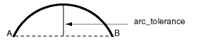
The arc_tolerance keyword specifies, for each arc in the geometry, the maximum length of the perpendicular line between the surface of the arc and the straight line between the start and end points of the arc. Figure 12-1 shows a line whose length is the arc_tolerance value for the arc between points A and B.
The arc_tolerance keyword value must be greater than or equal to the tolerance value associated with the geometry. As you increase the arc_tolerance keyword value, the resulting polygon has fewer sides and a smaller area; as you decrease the arc_tolerance keyword value, the resulting polygon has more sides and a larger area (but never larger than the original geometry).
If the unit keyword is specified, the value must be an SDO_UNIT value from the MDSYS.SDO_DIST_UNITS table (for example, 'unit=KM'). If the unit keyword is not specified, the unit of measurement associated with the geometry is used. See Section 2.6 for more information about unit of measurement specification.
If the function format with tol is used, all geometry objects must be defined using 4-digit SDO_GTYPE values (explained in Section 2.2.1).
The following example returns the geometry that results from the arc densification of cola_d, which is a circle. (The example uses the definitions and data from Section 2.1.)
-- Arc densification of the circle cola_d
SELECT c.name, SDO_GEOM.SDO_ARC_DENSIFY(c.shape, m.diminfo,
                                       'arc_tolerance=0.05')
  FROM cola_markets c, user_sdo_geom_metadata m
  WHERE m.table_name = 'COLA_MARKETS' AND m.column_name = 'SHAPE'
  AND c.name = 'cola_d';

NAME
--------------------------------
SDO_GEOM.SDO_ARC_DENSIFY(C.SHAPE,M.DIMINFO,'ARC_TOLERANCE=0.05')(SDO_GTYPE, SDO_
--------------------------------------------------------------------------------
cola_d
SDO_GEOMETRY(2003, NULL, NULL, SDO_ELEM_INFO_ARRAY(1, 1003, 1), SDO_ORDINATE_ARR
AY(8, 7, 8.76536686, 7.15224093, 9.41421356, 7.58578644, 9.84775907, 8.23463314,
 10, 9, 9.84775907, 9.76536686, 9.41421356, 10.4142136, 8.76536686, 10.8477591,
8, 11, 7.23463314, 10.8477591, 6.58578644, 10.4142136, 6.15224093, 9.76536686, 6
, 9, 6.15224093, 8.23463314, 6.58578644, 7.58578644, 7.23463314, 7.15224093, 8,
7))
SDO_GEOM.SDO_AREA(
or
SDO_GEOM.SDO_AREA(
Returns the area of a two-dimensional polygon.
Geometry object.
Dimensional information array corresponding to geom, usually selected from one of the xxx_SDO_GEOM_METADATA views (see Section 2.4).
Unit of measurement: a quoted string with unit= and an SDO_UNIT value from the MDSYS.SDO_AREA_UNITS table (for example, 'unit=SQ_KM'). See Section 2.6 for more information about unit of measurement specification.
If this parameter is not specified, the unit of measurement associated with the data is assumed. For geodetic data, the default unit of measurement is square meters.
Tolerance value (see Section 1.5.5).
This function works with any polygon, including polygons with holes.
This function does not support the units parameter that is included with the LOCATOR_WITHIN_DISTANCE operator of interMedia Locator, which is a component of the Oracle interMedia product.
If the function format with tol is used, all geometry objects must be defined using 4-digit SDO_GTYPE values (explained in Section 2.2.1).
The following example returns the areas of geometry objects stored in the COLA_MARKETS table. The first statement returns the areas all objects; the second returns just the area of cola_a. (The example uses the definitions and data from Section 2.1.)
-- Return the areas of all cola markets.
SELECT name, SDO_GEOM.SDO_AREA(shape, 0.005) FROM cola_markets;

NAME                             SDO_GEOM.SDO_AREA(SHAPE,0.005)
-------------------------------- ------------------------------
cola_a                                                       24
cola_b                                                     16.5
cola_c                                                        5
cola_d                                               12.5663706

-- Return the area of just cola_a.
SELECT c.name, SDO_GEOM.SDO_AREA(c.shape, 0.005) FROM cola_markets c
   WHERE c.name = 'cola_a';

NAME                             SDO_GEOM.SDO_AREA(C.SHAPE,0.005)
-------------------------------- --------------------------------
cola_a                                                         24
None.
SDO_GEOM.SDO_BUFFER(
geom IN MDSYS.SDO_GEOMETRY,
dim IN MDSYS.SDO_DIM_ARRAY,
dist IN NUMBER
[, params IN VARCHAR2]
) RETURN MDSYS.SDO_GEOMETRY;
or
SDO_GEOM.SDO_BUFFER(
geom IN MDSYS.SDO_GEOMETRY,
dist IN NUMBER,
tol IN NUMBER
[, params IN VARCHAR2]
) RETURN MDSYS.SDO_GEOMETRY;
Generates a buffer polygon around a geometry object.
Geometry object.
Dimensional information array corresponding to geom, usually selected from one of the xxx_SDO_GEOM_METADATA views (see Section 2.4).
Euclidean distance value. Must be greater than the tolerance value, as specified in the dimensional array (dim parameter) or in the tol parameter.
Tolerance value (see Section 1.5.5).
A quoted string with one or both of the following keywords:
For example: 'unit=km arc_tolerance=0.05'
If the input geometry is geodetic data, this parameter is required, and arc_tolerance must be specified. If the input geometry is Cartesian or projected data, arc_tolerance has no effect and should not be specified.
If this parameter is not specified for a Cartesian or projected geometry, or if the arc_tolerance keyword is specified for a geodetic geometry but the unit keyword is not specified, the unit of measurement associated with the data is assumed.
This function returns a geometry object representing the buffer polygon.
This function creates a rounded buffer around a point, line, or polygon. The buffer within a void is also rounded, and is the same distance from the inner boundary as the outer buffer is from the outer boundary. See Figure 1-11 for an illustration.
If the function format with tol is used, all geometry objects must be defined using 4-digit SDO_GTYPE values (explained in Section 2.2.1).
With geodetic data, this function is supported by approximations, as explained in Section 5.7.2.
This function does not support the units parameter that is included with the LOCATOR_WITHIN_DISTANCE operator of interMedia Locator, which is a component of the Oracle interMedia product.
The following example returns a polygon representing a buffer of 1 around cola_a. Note the "rounded" corners (for example, at .292893219,.292893219) in the returned polygon. (The example uses the non-geodetic definitions and data from Section 2.1.)
-- Generate a buffer of 1 unit around a geometry.
SELECT c.name, SDO_GEOM.SDO_BUFFER(c.shape, m.diminfo, 1)
  FROM cola_markets c, user_sdo_geom_metadata m
  WHERE m.table_name = 'COLA_MARKETS'  AND m.column_name = 'SHAPE'
  AND c.name = 'cola_a';

NAME
--------------------------------
SDO_GEOM.SDO_BUFFER(C.SHAPE,M.DIMINFO,1)(SDO_GTYPE, SDO_SRID, SDO_POINT(X, Y, Z)
--------------------------------------------------------------------------------
cola_a
SDO_GEOMETRY(2003, NULL, NULL, SDO_ELEM_INFO_ARRAY(1, 1005, 8, 1, 2, 2, 5, 2, 1,
 7, 2, 2, 11, 2, 1, 13, 2, 2, 17, 2, 1, 19, 2, 2, 23, 2, 1), SDO_ORDINATE_ARRAY(
0, 1, .292893219, .292893219, 1, 0, 5, 0, 5.70710678, .292893219, 6, 1, 6, 7, 5.
70710678, 7.70710678, 5, 8, 1, 8, .292893219, 7.70710678, 0, 7, 0, 1))
The following example returns a polygon representing a buffer of 1 around cola_a using the geodetic definitions and data from Section 5.8.
-- Generate a buffer of 1 kilometer around a geometry.
SELECT c.name, SDO_GEOM.SDO_BUFFER(c.shape, m.diminfo, 1,
                                  'unit=km arc_tolerance=0.05')
 FROM cola_markets c, user_sdo_geom_metadata m
 WHERE m.table_name = 'COLA_MARKETS'
 AND m.column_name = 'SHAPE' AND c.name = 'cola_a';

NAME
--------------------------------
SDO_GEOM.SDO_BUFFER(C.SHAPE,M.DIMINFO,1,'UNIT=KMARC_TOLERANCE=0.05')(SDO_GTYPE,
--------------------------------------------------------------------------------
cola_a
SDO_GEOMETRY(2003, 8307, NULL, SDO_ELEM_INFO_ARRAY(1, 1003, 1), SDO_ORDINATE_ARR
AY(.991023822, 1.00002073, .992223711, .995486419, .99551726, .99217077, 1.00001
929, .990964898, 4.99998067, .990964929, 5.00448268, .9921708, 5.00777624, .9954
86449, 5.00897618, 1.00002076, 5.00904194, 6.99997941, 5.00784065, 7.00450033, 5
.00454112, 7.00781357, 5.00002479, 7.009034, .999975166, 7.00903403, .995458814,
 7.00781359, .992159303, 7.00450036, .990958058, 6.99997944, .991023822, 1.00002
073))
SDO_GEOM.SDO_CENTROID(
or
SDO_GEOM.SDO_CENTROID(
Returns a point geometry that is the centroid of a polygon, multipolygon, point, or point cluster. (The centroid is also known as the "center of gravity.")
For an input geometry consisting of multiple objects, the result is weighted by the area of each polygon in the geometry objects. If the geometry objects are a mixture of polygons and points, the points are not used in the calculation of the centroid. If the geometry objects are all points, the points have equal weight.
Geometry object.
Dimensional information array corresponding to geom, usually selected from one of the xxx_SDO_GEOM_METADATA views (see Section 2.4).
Tolerance value (see Section 1.5.5).
The function returns a null value if geom is not a polygon, multipolygon, point, or point cluster.
If geom1 is a point, the function returns the point (the input geometry).
If the function format with tol is used, all geometry objects must be defined using 4-digit SDO_GTYPE values (explained in Section 2.2.1).
With geodetic data, this function is supported by approximations, as explained in Section 5.7.2.
The following example returns a geometry object that is the centroid of cola_c. (The example uses the definitions and data from Section 2.1.)
-- Return the centroid of a geometry.
SELECT c.name, SDO_GEOM.SDO_CENTROID(c.shape, m.diminfo)
  FROM cola_markets c, user_sdo_geom_metadata m
  WHERE m.table_name = 'COLA_MARKETS' AND m.column_name = 'SHAPE'
  AND c.name = 'cola_c';

NAME
--------------------------------
SDO_GEOM.SDO_CENTROID(C.SHAPE,M.DIMINFO)(SDO_GTYPE, SDO_SRID, SDO_POINT(X, Y, Z)
--------------------------------------------------------------------------------
cola_c
SDO_GEOMETRY(2001, NULL, NULL, SDO_ELEM_INFO_ARRAY(1, 1, 1), SDO_ORDINATE_ARRAY(
4.73333333, 3.93333333))
None.
SDO_GEOM.SDO_CONVEXHULL(
or
SDO_GEOM.SDO_CONVEXHULL(
Returns a polygon-type object that represents the convex hull of a geometry object.
Geometry object.
Dimensional information array corresponding to geom, usually selected from one of the xxx_SDO_GEOM_METADATA views (see Section 2.4).
Tolerance value (see Section 1.5.5).
The convex hull is a simple convex polygon that completely encloses the geometry object. Spatial uses as few straight-line sides as possible to create the smallest polygon that completely encloses the specified object. A convex hull is a convenient way to get an approximation of a complex geometry object.
If the geometry (geom1) contains any arc elements, the function calculates the minimum bounding rectangle (MBR) for each arc element and uses these MBRs in calculating the convex hull of the geometry. If the geometry object (geom1) is a circle, the function returns a square that minimally encloses the circle.
The function returns the original (input) geometry if geom is of point type, has fewer than three points or vertices, or consists of multiple points all in a straight line.
If the function format with tol is used, all geometry objects must be defined using 4-digit SDO_GTYPE values (explained in Section 2.2.1).
With geodetic data, this function is supported by approximations, as explained in Section 5.7.2.
The following example returns a geometry object that is the convex hull of cola_c. (The example uses the definitions and data from Section 2.1. This specific example, however, does not produce useful output -- the returned polygon is identical to the input polygon -- because the input polygon is already a simple convex polygon.)
-- Return the convex hull of a polygon.
SELECT c.name, SDO_GEOM.SDO_CONVEXHULL(c.shape, m.diminfo)
  FROM cola_markets c, user_sdo_geom_metadata m
  WHERE m.table_name = 'COLA_MARKETS' AND m.column_name = 'SHAPE'
  AND c.name = 'cola_c';

NAME
--------------------------------
SDO_GEOM.SDO_CONVEXHULL(C.SHAPE,M.DIMINFO)(SDO_GTYPE, SDO_SRID, SDO_POINT(X, Y,
--------------------------------------------------------------------------------
cola_c
SDO_GEOMETRY(2003, NULL, NULL, SDO_ELEM_INFO_ARRAY(1, 1003, 1), SDO_ORDINATE_ARR
AY(6, 3, 6, 5, 4, 5, 3, 3, 6, 3))
None.
SDO_GEOM.SDO_DIFFERENCE(
geom1 IN MDSYS.SDO_GEOMETRY,
dim1 IN MDSYS.SDO_DIM_ARRAY,
geom2 IN MDSYS.SDO_GEOMETRY,
dim2 IN MDSYS.SDO_DIM_ARRAY
) RETURN MDSYS.SDO_GEOMETRY;
or
SDO_GEOM.SDO_DIFFERENCE(
geom1 IN MDSYS.SDO_GEOMETRY,
geom2 IN MDSYS.SDO_GEOMETRY,
tol IN NUMBER
) RETURN MDSYS.SDO_GEOMETRY;
Returns a geometry object that is the topological difference (MINUS operation) of two geometry objects.
Geometry object.
Dimensional information array corresponding to geom1, usually selected from one of the xxx_SDO_GEOM_METADATA views (see Section 2.4).
Geometry object.
Dimensional information array corresponding to geom2, usually selected from one of the xxx_SDO_GEOM_METADATA views (see Section 2.4).
Tolerance value (see Section 1.5.5).
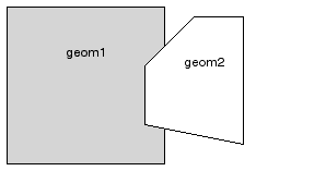
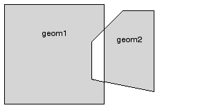
In Figure 12-2, the shaded area represents the polygon returned when SDO_DIFFERENCE is used with a square (geom1) and another polygon (geom2).
If the function format with tol is used, all geometry objects must be defined using 4-digit SDO_GTYPE values (explained in Section 2.2.1).
An exception is raised if geom1 and geom2 are based on different coordinate systems.
You should use this function instead of the deprecated function SDO_GEOM.SDO_POLY_DIFFERENCE.
The following example returns a geometry object that is the topological difference (MINUS operation) of cola_a and cola_c. (The example uses the definitions and data from Section 2.1.)
-- Return the topological difference of two geometries.
SELECT SDO_GEOM.SDO_DIFFERENCE(c_a.shape, m.diminfo, c_c.shape, m.diminfo)
  FROM cola_markets c_a, cola_markets c_c, user_sdo_geom_metadata m
  WHERE m.table_name = 'COLA_MARKETS' AND m.column_name = 'SHAPE'
  AND c_a.name = 'cola_a' AND c_c.name = 'cola_c';

SDO_GEOM.SDO_DIFFERENCE(C_A.SHAPE,M.DIMINFO,C_C.SHAPE,M.DIMINFO)(SDO_GTYPE, SDO_
--------------------------------------------------------------------------------
SDO_GEOMETRY(2003, NULL, NULL, SDO_ELEM_INFO_ARRAY(1, 1003, 1), SDO_ORDINATE_ARR
AY(1, 7, 1, 1, 5, 1, 5, 3, 3, 3, 4, 5, 5, 5, 5, 7, 1, 7)
Note that in the returned polygon, the SDO_ORDINATE_ARRAY starts and ends at the same point (1, 7).
SDO_GEOM.SDO_DISTANCE(
geom1 IN MDSYS.SDO_GEOMETRY,
dim1 IN MDSYS.SDO_DIM_ARRAY,
geom2 IN MDSYS.SDO_GEOMETRY,
dim2 IN MDSYS.SDO_DIM_ARRAY
[, unit IN VARCHAR2]
) RETURN NUMBER;
or
SDO_GEOM.SDO_DISTANCE(
geom1 IN MDSYS.SDO_GEOMETRY,
geom2 IN MDSYS.SDO_GEOMETRY,
tol IN NUMBER
[, unit IN VARCHAR2]
) RETURN NUMBER;
Computes the distance between two geometry objects. The distance between two geometry objects is the distance between the closest pair of points or segments of the two objects.
Geometry object whose distance from geom2 is to be computed.
Dimensional information array corresponding to geom1, usually selected from one of the xxx_SDO_GEOM_METADATA views (see Section 2.4).
Geometry object whose distance from geom1 is to be computed.
Dimensional information array corresponding to geom2, usually selected from one of the xxx_SDO_GEOM_METADATA views (see Section 2.4).
Unit of measurement: a quoted string with unit= and an SDO_UNIT value from the MDSYS.SDO_DIST_UNITS table (for example, 'unit=KM'). See Section 2.6 for more information about unit of measurement specification.
If this parameter is not specified, the unit of measurement associated with the data is assumed.
Tolerance value (see Section 1.5.5).
This function does not support the units parameter that is included with the LOCATOR_WITHIN_DISTANCE operator of interMedia Locator, which is a component of the Oracle interMedia product.
If the function format with tol is used, all geometry objects must be defined using 4-digit SDO_GTYPE values (explained in Section 2.2.1).
An exception is raised if geom1 and geom2 are based on different coordinate systems.
The following example returns the shortest distance between cola_b and cola_d. (The example uses the definitions and data from Section 2.1.)
-- Return the distance between two geometries.
SELECT SDO_GEOM.SDO_DISTANCE(c_b.shape, c_d.shape, 0.005)
   FROM cola_markets c_b, cola_markets c_d
   WHERE c_b.name = 'cola_b' AND c_d.name = 'cola_d';

SDO_GEOM.SDO_DISTANCE(C_B.SHAPE,C_D.SHAPE,0.005)
------------------------------------------------
                                      .846049894
SDO_GEOM.SDO_INTERSECTION(
geom1 IN MDSYS.SDO_GEOMETRY,
dim1 IN MDSYS.SDO_DIM_ARRAY,
geom2 IN MDSYS.SDO_GEOMETRY,
dim2 IN MDSYS.SDO_DIM_ARRAY
) RETURN MDSYS.SDO_GEOMETRY;
or
SDO_GEOM.SDO_INTERSECTION(
geom1 IN MDSYS.SDO_GEOMETRY,
geom2 IN MDSYS.SDO_GEOMETRY,
tol IN NUMBER
) RETURN MDSYS.SDO_GEOMETRY;
Returns a geometry object that is the topological intersection (AND operation) of two geometry objects.
Geometry object.
Dimensional information array corresponding to geom1, usually selected from one of the xxx_SDO_GEOM_METADATA views (see Section 2.4).
Geometry object.
Dimensional information array corresponding to geom2, usually selected from one of the xxx_SDO_GEOM_METADATA views (see Section 2.4).
Tolerance value (see Section 1.5.5).
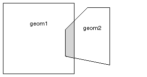
In Figure 12-3, the shaded area represents the polygon returned when SDO_INTERSECTION is used with a square (geom1) and another polygon (geom2).
If the function format with tol is used, all geometry objects must be defined using 4-digit SDO_GTYPE values (explained in Section 2.2.1).
An exception is raised if geom1 and geom2 are based on different coordinate systems.
You should use this function instead of the deprecated function SDO_GEOM.SDO_POLY_INTERSECTION.
The following example returns a geometry object that is the topological intersection (AND operation) of cola_a and cola_c. (The example uses the definitions and data from Section 2.1.)
-- Return the topological intersection of two geometries.
SELECT SDO_GEOM.SDO_INTERSECTION(c_a.shape, c_c.shape, 0.005)
   FROM cola_markets c_a, cola_markets c_c
   WHERE c_a.name = 'cola_a' AND c_c.name = 'cola_c';

SDO_GEOM.SDO_INTERSECTION(C_A.SHAPE,C_C.SHAPE,0.005)(SDO_GTYPE, SDO_SRID, SDO_PO
--------------------------------------------------------------------------------
SDO_GEOMETRY(2003, NULL, NULL, SDO_ELEM_INFO_ARRAY(1, 1003, 1), SDO_ORDINATE_ARR
AY(4, 5, 3, 3, 5, 3, 5, 5, 4, 5))
Note that in the returned polygon, the SDO_ORDINATE_ARRAY starts and ends at the same point (4, 5).
SDO_GEOM.SDO_LENGTH(
or
SDO_GEOM.SDO_LENGTH(
Returns the length or perimeter of a geometry object.
Geometry object.
Dimensional information array corresponding to geom, usually selected from one of the xxx_SDO_GEOM_METADATA views (see Section 2.4).
Unit of measurement: a quoted string with unit= and an SDO_UNIT value from the MDSYS.SDO_DIST_UNITS table (for example, 'unit=KM'). See Section 2.6 for more information about unit of measurement specification.
If this parameter is not specified, the unit of measurement associated with the data is assumed. For geodetic data, the default unit of measurement is meters.
Tolerance value (see Section 1.5.5).
If the input polygon contains one or more holes, this function calculates the perimeters of the exterior boundary and all holes. It returns the sum of all the perimeters.
If the function format with tol is used, all geometry objects must be defined using 4-digit SDO_GTYPE values (explained in Section 2.2.1).
This function does not support the units parameter that is included with the LOCATOR_WITHIN_DISTANCE operator of interMedia Locator, which is a component of the Oracle interMedia product.
The following example returns the perimeters of geometry objects stored in the COLA_MARKETS table. The first statement returns the perimeters of all objects; the second returns just the perimeter of cola_a. (The example uses the definitions and data from Section 2.1.)
-- Return the perimeters of all cola markets.
SELECT c.name, SDO_GEOM.SDO_LENGTH(c.shape, m.diminfo)
  FROM cola_markets c, user_sdo_geom_metadata m
  WHERE m.table_name = 'COLA_MARKETS' AND m.column_name = 'SHAPE';

NAME                             SDO_GEOM.SDO_LENGTH(C.SHAPE,M.DIMINFO)
-------------------------------- --------------------------------------
cola_a                                                               20
cola_b                                                       17.1622777
cola_c                                                       9.23606798
cola_d                                                       12.5663706

-- Return the perimeter of just cola_a.
SELECT c.name, SDO_GEOM.SDO_LENGTH(c.shape, m.diminfo)
  FROM cola_markets c, user_sdo_geom_metadata m
  WHERE m.table_name = 'COLA_MARKETS' AND m.column_name = 'SHAPE'
  AND c.name = 'cola_a';

NAME                             SDO_GEOM.SDO_LENGTH(C.SHAPE,M.DIMINFO)
-------------------------------- --------------------------------------
cola_a                                                               20
None.
SDO_GEOM.SDO_MAX_MBR_ORDINATE(
or
SDO_GEOM.SDO_MAX_MBR_ORDINATE(
Returns the maximum value for the specified ordinate of the minimum bounding rectangle of a geometry object.
Geometry object.
Dimensional information array corresponding to geom, usually selected from one of the xxx_SDO_GEOM_METADATA views (see Section 2.4).
Position of the ordinate in the definition of the geometry object: 1 for the first ordinate, 2 for the second ordinate, and so on. For example, if geom has X, Y ordinates, 1 identifies the X ordinate and 2 identifies the Y ordinate.
This function is not supported with geodetic data.
The following example returns the maximum X (first) ordinate value of the minimum bounding rectangle of the cola_d geometry in the COLA_MARKETS table. (The example uses the definitions and data from Section 2.1. The minimum bounding rectangle of cola_d is returned in the example for the SDO_GEOM.SDO_MBR function.)
SELECT SDO_GEOM.SDO_MAX_MBR_ORDINATE(c.shape, m.diminfo, 1)
  FROM cola_markets c, user_sdo_geom_metadata m
  WHERE m.table_name = 'COLA_MARKETS' AND m.column_name = 'SHAPE'
  AND c.name = 'cola_d';

SDO_GEOM.SDO_MAX_MBR_ORDINATE(C.SHAPE,M.DIMINFO,1)
--------------------------------------------------
                                                10
SDO_GEOM.SDO_MBR(
Returns the minimum bounding rectangle of a geometry object, that is, a single rectangle that minimally encloses the geometry.
Geometry object.
Dimensional information array corresponding to geom, usually selected from one of the xxx_SDO_GEOM_METADATA views (see Section 2.4).
This function is not supported with geodetic data.
The following example returns the minimum bounding rectangle of the cola_d geometry in the COLA_MARKETS table. (The example uses the definitions and data from Section 2.1. Because cola_d is a circle, the minimum bounding rectangle in this case is a square.)
-- Return the minimum bounding rectangle of cola_d (a circle).
SELECT SDO_GEOM.SDO_MBR(c.shape, m.diminfo)
  FROM cola_markets c, user_sdo_geom_metadata m
  WHERE m.table_name = 'COLA_MARKETS' AND m.column_name = 'SHAPE'
  AND c.name = 'cola_d';

SDO_GEOM.SDO_MBR(C.SHAPE,M.DIMINFO)(SDO_GTYPE, SDO_SRID, SDO_POINT(X, Y, Z), SDO
--------------------------------------------------------------------------------
SDO_GEOMETRY(2003, NULL, NULL, SDO_ELEM_INFO_ARRAY(1, 1003, 3), SDO_ORDINATE_ARR
AY(6, 7, 10, 11))
SDO_GEOM.SDO_MIN_MBR_ORDINATE(
or
SDO_GEOM.SDO_MIN_MBR_ORDINATE(
Returns the minimum value for the specified ordinate of the minimum bounding rectangle of a geometry object.
Geometry object.
Dimensional information array corresponding to geom, usually selected from one of the xxx_SDO_GEOM_METADATA views (see Section 2.4).
Position of the ordinate in the definition of the geometry object: 1 for the first ordinate, 2 for the second ordinate, and so on. For example, if geom has X, Y ordinates, 1 identifies the X ordinate and 2 identifies the Y ordinate.
This function is not supported with geodetic data.
The following example returns the minimum X (first) ordinate value of the minimum bounding rectangle of the cola_d geometry in the COLA_MARKETS table. (The example uses the definitions and data from Section 2.1. The minimum bounding rectangle of cola_d is returned in the example for the SDO_GEOM.SDO_MBR function.)
SELECT SDO_GEOM.SDO_MIN_MBR_ORDINATE(c.shape, m.diminfo, 1)
  FROM cola_markets c, user_sdo_geom_metadata m
  WHERE m.table_name = 'COLA_MARKETS' AND m.column_name = 'SHAPE'
  AND c.name = 'cola_d';

SDO_GEOM.SDO_MIN_MBR_ORDINATE(C.SHAPE,M.DIMINFO,1)
--------------------------------------------------
                                                 6
SDO_GEOM.SDO_POINTONSURFACE(
or
SDO_GEOM.SDO_POINTONSURFACE(
Returns a point that is guaranteed to be on the surface of a polygon geometry object.
Polygon geometry object.
Dimensional information array corresponding to geom, usually selected from one of the xxx_SDO_GEOM_METADATA views (see Section 2.4).
Tolerance value (see Section 1.5.5).
This function returns a point geometry object representing a point that is guaranteed to be on the surface of geom1.
The returned point can be any point on the surface. You should not make any assumptions about where on the surface the returned point is, or about whether the point is the same or different when the function is called multiple times with the same input parameter values.
If the function format with tol is used, all geometry objects must be defined using 4-digit SDO_GTYPE values (explained in Section 2.2.1).
The following example returns a geometry object that is a point on the surface of cola_a. (The example uses the definitions and data from Section 2.1.)
-- Return a point on the surface of a geometry.
SELECT SDO_GEOM.SDO_POINTONSURFACE(c.shape, m.diminfo)
  FROM cola_markets c, user_sdo_geom_metadata m
  WHERE m.table_name = 'COLA_MARKETS' AND m.column_name = 'SHAPE'
  AND c.name = 'cola_a';

SDO_GEOM.SDO_POINTONSURFACE(C.SHAPE,M.DIMINFO)(SDO_GTYPE, SDO_SRID, SDO_POINT(X,
--------------------------------------------------------------------------------
SDO_GEOMETRY(2001, NULL, NULL, SDO_ELEM_INFO_ARRAY(1, 1, 1), SDO_ORDINATE_ARRAY(
1, 1))
None.
SDO_GEOM.SDO_UNION(
geom1 IN MDSYS.SDO_GEOMETRY,
dim1 IN MDSYS.SDO_DIM_ARRAY,
geom2 IN MDSYS.SDO_GEOMETRY,
dim2 IN MDSYS.SDO_DIM_ARRAY
) RETURN MDSYS.SDO_GEOMETRY;
or
SDO_GEOM.SDO_UNION(
geom1 IN MDSYS.SDO_GEOMETRY,
geom2 IN MDSYS.SDO_GEOMETRY,
tol IN NUMBER
) RETURN MDSYS.SDO_GEOMETRY;
Returns a geometry object that is the topological union (OR operation) of two geometry objects.
Geometry object.
Dimensional information array corresponding to geom1, usually selected from one of the xxx_SDO_GEOM_METADATA views (see Section 2.4).
Geometry object.
Dimensional information array corresponding to geom2, usually selected from one of the xxx_SDO_GEOM_METADATA views (see Section 2.4).
Tolerance value (see Section 1.5.5).
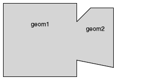
In Figure 12-4, the shaded area represents the polygon returned when SDO_UNION is used with a square (geom1) and another polygon (geom2).
If the function format with tol is used, all geometry objects must be defined using 4-digit SDO_GTYPE values (explained in Section 2.2.1).
An exception is raised if geom1 and geom2 are based on different coordinate systems.
You should use this function instead of the deprecated function SDO_GEOM.SDO_POLY_UNION.
The following example returns a geometry object that is the topological union (OR operation) of cola_a and cola_c. (The example uses the definitions and data from Section 2.1.)
-- Return the topological intersection of two geometries.
SELECT SDO_GEOM.SDO_UNION(c_a.shape, m.diminfo, c_c.shape, m.diminfo)
  FROM cola_markets c_a, cola_markets c_c, user_sdo_geom_metadata m
  WHERE m.table_name = 'COLA_MARKETS' AND m.column_name = 'SHAPE'
  AND c_a.name = 'cola_a' AND c_c.name = 'cola_c';

SDO_GEOM.SDO_UNION(C_A.SHAPE,M.DIMINFO,C_C.SHAPE,M.DIMINFO)(SDO_GTYPE, SDO_SRID,
--------------------------------------------------------------------------------
SDO_GEOMETRY(2003, NULL, NULL, SDO_ELEM_INFO_ARRAY(1, 1003, 1), SDO_ORDINATE_ARR
AY(5, 5, 5, 7, 1, 7, 1, 1, 5, 1, 5, 3, 6, 3, 6, 5, 5, 5))
Note that in the returned polygon, the SDO_ORDINATE_ARRAY starts and ends at the same point (5, 5).
SDO_GEOM.SDO_XOR(
geom1 IN MDSYS.SDO_XOR,
dim1 IN MDSYS.SDO_DIM_ARRAY,
geom2 IN MDSYS.SDO_GEOMETRY,
dim2 IN MDSYS.SDO_DIM_ARRAY
) RETURN MDSYS.SDO_GEOMETRY;
or
SDO_GEOM.SDO_XOR(
geom1 IN MDSYS.SDO_GEOMETRY,
geom2 IN MDSYS.SDO_GEOMETRY,
tol IN NUMBER
) RETURN MDSYS.SDO_GEOMETRY;
Returns a geometry object that is the topological symmetric difference (XOR operation) of two geometry objects.
Geometry object.
Dimensional information array corresponding to geom1, usually selected from one of the xxx_SDO_GEOM_METADATA views (see Section 2.4).
Geometry object.
Dimensional information array corresponding to geom2, usually selected from one of the xxx_SDO_GEOM_METADATA views (see Section 2.4).
Tolerance value (see Section 1.5.5).
In Figure 12-5, the shaded area represents the polygon returned when SDO_XOR is used with a square (geom1) and another polygon (geom2).
If the function format with tol is used, all geometry objects must be defined using 4-digit SDO_GTYPE values (explained in Section 2.2.1).
An exception is raised if geom1 and geom2 are based on different coordinate systems.
You should use this function instead of the deprecated function SDO_GEOM.SDO_POLY_XOR.
The following example returns a geometry object that is the topological symmetric difference (XOR operation) of cola_a and cola_c. (The example uses the definitions and data from Section 2.1.)
-- Return the topological symmetric difference of two geometries.
SELECT SDO_GEOM.SDO_XOR(c_a.shape, m.diminfo, c_c.shape, m.diminfo)
  FROM cola_markets c_a, cola_markets c_c, user_sdo_geom_metadata m
  WHERE m.table_name = 'COLA_MARKETS' AND m.column_name = 'SHAPE'
  AND c_a.name = 'cola_a' AND c_c.name = 'cola_c';

SDO_GEOM.SDO_XOR(C_A.SHAPE,M.DIMINFO,C_C.SHAPE,M.DIMINFO)(SDO_GTYPE, SDO_SRID, S
--------------------------------------------------------------------------------
SDO_GEOMETRY(2007, NULL, NULL, SDO_ELEM_INFO_ARRAY(1, 1003, 1, 19, 1003, 1), SDO
_ORDINATE_ARRAY(1, 7, 1, 1, 5, 1, 5, 3, 3, 3, 4, 5, 5, 5, 5, 7, 1, 7, 5, 5, 5, 3
, 6, 3, 6, 5, 5, 5))
Note that in the returned polygon is a multipolygon (SDO_GTYPE = 2007), and the SDO_ORDINATE_ARRAY describes two polygons: one starting and ending at (1, 7) and the other starting and ending at (5, 5).
SDO_GEOM.VALIDATE_GEOMETRY(
or
SDO_GEOM.VALIDATE_GEOMETRY(
Performs a consistency check for valid geometry types. The function checks the representation of the geometry from the tables against the element definitions.
Geometry object.
Dimensional information array corresponding to geom, usually selected from one of the xxx_SDO_GEOM_METADATA views (see Section 2.4).
Tolerance value (see Section 1.5.5).
If the geometry is valid, this function returns TRUE.
If the geometry is not valid, this function returns one of the following:
This function checks for type consistency and geometry consistency.
For type consistency, the function checks for the following:
For geometry consistency, the function checks for the following, as appropriate for the specific geometry type:
In checking for geometry consistency, the function considers the geometry's tolerance value in determining if lines touch or if points are the same.
If the function format with tolerance is used, all geometry objects must be defined using 4-digit SDO_GTYPE values (explained in Section 2.2.1).
You can use this function in a PL/SQL procedure as an alternative to using the SDO_GEOM.VALIDATE_LAYER procedure. See the Usage Notes for SDO_GEOM.VALIDATE_LAYER for more information.
The following example validates the geometry of cola_c. (The example uses the definitions and data from Section 2.1.)
-- Is a geometry valid?
SELECT c.name, SDO_GEOM.VALIDATE_GEOMETRY(c.shape, 0.005)
   FROM cola_markets c WHERE c.name = 'cola_c';

NAME
--------------------------------
SDO_GEOM.VALIDATE_GEOMETRY(C.SHAPE,0.005)
--------------------------------------------------------------------------------
cola_c
TRUE
SDO_GEOM.VALIDATE_LAYER(
geom_table IN VARCHAR2,
geom_column IN VARCHAR2,
pkey_column IN VARCHAR2,
result_table IN VARCHAR2
[, commit_interval IN NUMBER]);
Examines a geometry column to determine if the stored geometries follow the defined rules for geometry objects.
Geometry table.
Geometry object column to be examined.
The primary key column. This must be a single numeric (NUMBER data type) column.
Result table to hold the validation results. A row is added to result_table for each invalid geometry. If there are no invalid geometries, one or more (depending on the commit_interval value) rows with a result of DONE are added.
Number of geometries to validate before Spatial performs an internal commit operation and writes a row with a result of DONE to result_table (if no rows for invalid geometries have been written since the last commit operation). If commit_interval is not specified, no internal commit operations are performed during the validation.
The commit_interval option is helpful if you want to look at the contents of result_table while the validation is in progress. If the primary key is indexed, you can look at the last PKEY_COLUMN value to see approximately how much of the validation is completed.
This procedure loads the result table with validation results. (VALIDATE_LAYER is a procedure, not a function.)
An empty result table (result_table parameter) must be created before calling this procedure. The format of the result table is: (pkey_column NUMBER, result VARCHAR2(10)). If result_table is not empty, you should truncate the table before calling the procedure; otherwise, the procedure appends rows to the existing data in the table.
The result table contains one row for each invalid geometry. A row is not written if a geometry is valid, except as follows:
In each row for an invalid geometry, the PKEY_COLUMN column contains the primary key value of the row containing the invalid geometry, and the RESULT column contains an Oracle error message number. You can then look up this error message to determine the cause of the failure.
This procedure performs the following checks on each geometry in the layer (geom_column):
As an alternative to using the VALIDATE_LAYER procedure, you can use a PL/SQL procedure that calls the SDO_GEOM.VALIDATE_GEOMETRY function for each input row and inserts rows in a result table for errors. With this approach, you have more options in defining the result table; for example, the key field can be a rowid or anything else that you choose.
The following example validates the geometry objects stored in the SHAPE column of the COLA_MARKETS table. The example includes the creation of the result table. (The example uses the definitions and data from Section 2.1.) In this case, a row with a RESULT value of DONE is written to the result table, because all the geometries are valid.
-- Is a layer valid? (First, create the result table.)
CREATE TABLE val_results (mkt_id number, result varchar2(10));
EXECUTE SDO_GEOM.VALIDATE_LAYER('COLA_MARKETS','SHAPE','MKT_ID','VAL_RESULTS');

PL/SQL procedure successfully completed.

SELECT * from val_results;

    MKT_ID RESULT
---------- ----------
           DONE
SDO_GEOM.WITHIN_DISTANCE(
geom1 IN MDSYS.SDO_GEOMETRY,
dim1 IN MDSYS.SDO_DIM_ARRAY,
dist IN NUMBER,
geom2 IN MDSYS.SDO_GEOMETRY,
dim2 IN MDSYS.SDO_DIM_ARRAY
) RETURN VARCHAR2;
or
SDO_GEOM.WITHIN_DISTANCE(
geom1 IN MDSYS.SDO_GEOMETRY,
dist IN NUMBER,
geom2 IN MDSYS.SDO_GEOMETRY,
tol IN NUMBER
) RETURN VARCHAR2;
Determines if two spatial objects are within some specified Euclidean distance from each other.
Geometry object.
Dimensional information array corresponding to geom1, usually selected from one of the xxx_SDO_GEOM_METADATA views (see Section 2.4).
Euclidean distance value.
Geometry object.
Dimensional information array corresponding to geom2, usually selected from one of the xxx_SDO_GEOM_METADATA views (see Section 2.4).
Tolerance value (see Section 1.5.5).
This function returns TRUE for object pairs that are within the specified distance, and FALSE otherwise.
The distance between two extended objects (for example, nonpoint objects such as lines and polygons) is defined as the minimum distance between these two objects. Thus the distance between two adjacent polygons is zero.
If the function format with tol is used, all geometry objects must be defined using 4-digit SDO_GTYPE values (explained in Section 2.2.1).
An exception is raised if geom1 and geom2 are based on different coordinate systems.
The following example checks if cola_b and cola_d are within 1 unit apart at the shortest distance between them. (The example uses the definitions and data from Section 2.1.)
-- Are two geometries within 1 unit of distance apart?
SELECT SDO_GEOM.WITHIN_DISTANCE(c_b.shape, m.diminfo, 1,
     c_d.shape, m.diminfo)
  FROM cola_markets c_b, cola_markets c_d, user_sdo_geom_metadata m
  WHERE m.table_name = 'COLA_MARKETS' AND m.column_name = 'SHAPE'
  AND c_b.name = 'cola_b' AND c_d.name = 'cola_d';

SDO_GEOM.WITHIN_DISTANCE(C_B.SHAPE,M.DIMINFO,1,C_D.SHAPE,M.DIMINFO)
--------------------------------------------------------------------------------
TRUE
|
|
 Copyright © 1996-2001, Oracle Corporation. All Rights Reserved. |
|