Mapping Locations to Geography ID Codes
To map locations to geography ID codes, use the WA_LOCN_MAP_DFN.GBL component.
EPM uses a hierarchical structure for the geography dimension based on geography ID codes and the geography tree. Locations roll up into geography ID codes for geographical regions.
This section discusses how to:
Review and load source table location codes.
Enter geography IDs and create a geography tree.
Map locations to geography IDs.
Review your location and geography ID mappings.
Warning! For best results, locations should be mapped to unique geographies. If you have employees who may work simultaneously in two different jobs within the same department but in different locations, then you must uniquely map locations to geographies to ensure that the Workforce Data Mart logic works correctly. Note that the geography dimension of the Workforce Data Mart is tree-based, so if you want to aggregate employee data from multiple locations, you can view the Workforce Data Mart at a higher, more aggregated level of the Geography dimension (that is, at a higher node in the Geography tree).
Page Used to Map Locations to Geography ID Codes
|
Page Name |
Definition Name |
Navigation |
Usage |
|---|---|---|---|
|
Geography ID Map |
WA_LOCN_MAP_DFN |
|
Map location codes to Geography IDs. These mappings are stored in the WA_LOCN_MAP_DFN table. |
Reviewing and Loading Source Table Location Codes
Review your HRMS location table. In Workforce Analytics, each location must roll up to a geographical region on the geography tree. For each of your locations, determine the type of geographical regions to which you want to map them.
For the first time setup, either load your HRMS locations to the LOCATION_D00 table without mapping, or manually enter the locations using the LOCATION_D00 page.
Entering Geography IDs and Creating a Geography Tree
Create a GEOGRAPHY tree in which the nodes of the tree are geography IDs. Enter the nodes of the GEOGRAPHY tree using the Geography page. The values are stored in the GEOGRAPHY_D00 table.
Geography ID Map Page
Use the Geography ID Map page (WA_LOCN_MAP_DFN) to map location codes to Geography IDs.
These mappings are stored in the WA_LOCN_MAP_DFN table.
Image: Geography ID Map setup page
This example illustrates the fields and controls on the Geography ID Map setup page. You can find definitions for the fields and controls later on this page.
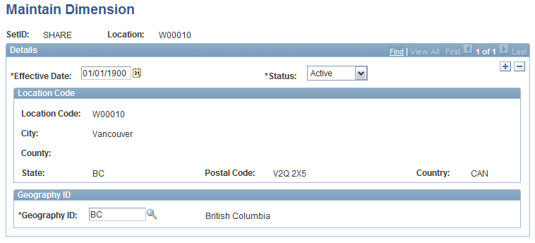
Location Code
The City,County,State,Postal Code, andCountry for thisLocation Code fields are supplied from the LOCATION_D00 table. Locations in different countries may display different address fields depending on the formatting that you previously defined in the Country Table, Address Format page.