Edit Background Maps For Dashboards and Analyses

You edit background maps to ensure that users have a seamless experience with map views in dashboards and analyses.

A background map is a non-interactive map that serves as a base for the map view. It might display a satellite image or a map with roads. The background map specifies the order of layers on the map view.

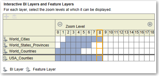
The ordering of map layers is very important. You must pay close attention to ensure that users have a seamless experience while navigating on the map (that is, drilling and zooming). In the Edit Background Map dialog, you assign each layer a minimum and maximum zoom range. Given that the map zoom slider can slide only from bottom to top vertically, the layers with lower minimum zoom levels are placed at the bottom of the slider. Ensure that the layer grid on the Interactive BI Layers section of the dialog follows a similar pattern, so that you place layers with lower minimum zoom levels at the bottom of the list.

Layer ordering becomes irrelevant when the zoom ranges of layers don’t intersect on the scale. Ordering becomes very important when layers have a common minimum and maximum zoom range. Use care to ensure that detailed layers aren’t hidden by the aggregated layers during drilling or zooming operations.
  1. Click the Background Maps tab, select a map, then click the Edit Background Map button to display the Edit Background Map dialog.
  2. Specify the name and description of the map, which is displayed as a tooltip for the map when selecting a map from the list, when editing the map view.
  3. The Location field displays the location of the background map in the data source. Click the Location button to change to a different map. If you select a background map that includes a different number of zoom levels, then the zoom levels are automatically adjusted for the layers that are associated with the map by scaling their ranges.
  4. Click the Add Layers button to display a list of the layers that have been imported on the Layers tab, then select the layers to add to the map. This button is unavailable when all layers from the Layers tab have been added to the background map.

    When you add a layer that’s part of the map definition, the layer displays at its default zoom levels. If the layer isn't part of the map definition, then specify the zoom levels yourself.

    The layers are listed from bottom to top, in terms of how they’re applied to the map. A sample order is Countries, States, Cities. The lower level layers generally have the lower zoom levels. For example, if you have a States layer and a Cities layer, then include lower zoom levels for State than City.


    Description of map_layers3.gif follows
    Description of the illustration map_layers3.gif
  5. Click the Sort Layers By Zoom Level button to list the layers in ascending or descending order based on visibility on the map. This button is unavailable when layers are listed in the proper order.
    The sort order that’s specified here doesn't affect the order in which layers are applied on the map. Instead, the sorting order affects the zoom levels. For example, the States layer might have zoom levels 1 through 3 and the Cities layer has zoom levels 4 through 9. The lower layers have the lower zoom level numbers. The zoom levels that you specify correspond to the tick marks on the zoom slider on the map.
    You can include both layers that have been associated with a column by using the Edit Layer dialog and layers that haven't been associated. Ensure that BI layers are ordered higher than non-BI layers. If a non-BI layer is ordered higher than any BI layers, then the non-BI layer is displayed on top of the lower BI layers on the map, which prevents the BI layers from being interactive.
  6. Click the Turn On Layer Visibility or Turn Off Layer Visibility button to control the visibility of layers on the map. Use the buttons to indicate whether the layer is visible in the Preview map in this dialog only. The layer is still visible on a map view. You can modify the zoom levels for a layer with a visibility turned off.
  7. Click a cell under a zoom level for a layer to affect the zoom level:
    • If you click a blue cell that’s between other blue cells, then you see a popup menu with Clear Before and Clear After buttons, which allow you to change the zoom level in either direction. For example, if you click the cell for zoom level 4 and click the eraser on the right, then all cells to the right are cleared for that zoom level.

    • If you click a blue cell that at the end of a line of blue cells, then the cell turns white to indicate that it's no longer part of that zoom level.

    • If you click a white cell, then you increase the zoom level on either side of the existing blue cells. For example, suppose cells 4 through 6 are colored blue to reflect the zoom level. If you click in cell 2, then the zoom level becomes 2 through 6.

    If you don’t set any zoom levels for a layer, then that layer doesn't display on the map.
  8. Click the action icon beside the layer name to display a menu from which you can make various selections:
    • Delete — Removes the layer from this background map. The layer continues to be available on the Layers tab and can be added to this area again.

    • Move Up or Move Down — Moves the layer up or down so you can specify the order in which layers are applied to the map.

    • Reset to Default Visibility — Resets the current visibility range for this layer as defined in the underlying map definition. If this layer isn't natively associated with the map, then this option is disabled for that layer.

  9. Use the yellow border that surrounds the column of boxes for a zoom level to determine which zoom level is currently displayed in the map area.
  10. Use the panning and zooming controls to specify how the map is displayed to users. If you hover over the zoom slider, then you see tooltips that specify the names of the layers that are currently associated with that zoom level.
  11. Click OK.