1.1 Overview of the Map Visualization Component
The map visualization component enables developers to incorporate highly interactive maps and spatial analysis into business applications.
Application content can be combined with maps and data from a variety of web services and data formats such as GeoJSON. It is deployed in a Java EE container or in the Oracle Java Cloud Service.
The map visualization component includes the following:
-
A map rendering engine to expose cartographic render functions to web applications.
-
A suite of application programming interfaces (APIs) that allow programmable access to visualization features. These APIs include XML, Java, and an HTML5-based JavaScript API.
-
A graphical map builder tool that enables you to create map symbols, define spatial data rendering rules, and create and edit map visualization component objects.
-
Oracle Maps, which includes map cache and FOI (feature of interest) servers that facilitate the development of interactive geospatial web applications.
-
Packaged content for admin areas (countries, states, counties, and so on) as JSON files.
The core rendering engine connects to the Oracle database through Java Database Connectivity (JDBC). It also reads the map metadata (such as map definitions, styling rules, and symbology created through the Map Builder tool) from the database, and applies the metadata to the retrieved spatial data during rendering operations.
The JavaScript API enables you to create highly interactive web applications that use the Oracle Maps feature of the map visualization component.
The Map Builder tool simplifies the process of creating and managing map, theme, and symbology metadata in a spatial database. For information about this tool, see Oracle Map Builder Tool.
Oracle Maps, built on core map visualization component features, uses a map tile server that caches map image tiles, and a feature of interest (FOI) server that streams live data out of a database to be displayed as interactive features on a map. You can use the HTML5-based JavaScript API with Oracle Maps to provide sophisticated mapping solutions. Oracle Maps also allows for advanced customization and querying capabilities.
The map visualization component supports two-dimensional vector geometries stored in Oracle Spatial, as well as GeoRaster data and data in the Oracle Spatial topology and network data models. The map visualization component is also an Open Geospatial Consortium (OGC)-compliant web map service (WMS) and web map tile service (WMTS) server.
The
Parent topic: Introduction to the Map Visualization Component 23.2
1.1.1 Map Visualization Component Architecture
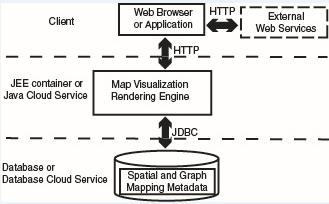
The following figure illustrates the architecture of the map visualization component.
Figure 1-1 Map Visualization Component Architecture

Description of "Figure 1-1 Map Visualization Component Architecture"
As shown in the preceding figure:
-
The map visualization component can communicate with a client web browser or application or external web services using the HTTP protocol.
-
With a client web browser or application, it communicates using HTTP protocol with the map visualization rendering engine in a JEE container or the Java cloud service.
-
It performs spatial data access (reading and writing Oracle Spatial data) through JDBC calls to the database or the database cloud service.
-
The database or database cloud service includes Oracle Spatial, as well as mapping metadata.
Parent topic: Overview of the Map Visualization Component