C.3 Rendering the External Spatial Data
To enable you to render the sample external spatial data that comes with the map visualization component kit, create a data source pointing to this data.
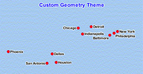
Example C-2 is an XML request that contains a dynamic custom geometry theme.
Example C-2 Map Request to Render External Spatial Data
<?xml version="1.0" standalone="yes"?>
<map_request
 title="Custom Geometry Theme"
 datasource="mvdemo"
 width="500"
 height="400"
 bgcolor="#a6caf0"
 antialiase="true"
 format="PNG_STREAM"
>
 <center size="40">
   <geoFeature>
     <geometricProperty typeName="center">
       <Point>
         <coordinates>-90,32</coordinates>
       </Point>
     </geometricProperty>
   </geoFeature>
 </center>

 <themes>
   <theme name="custom_theme" >
      <custom_geom_theme
        provider_id="xmlProvider"
        srid="8307"
        render_style="M.CIRCLE"
        label_column="city"
        label_style="T.CITY NAME"
        datasource="mvdemo">
      <parameters>
       <parameter name="filename" value="/lbs/demo/spatialprovider/us_bigcities.xml"/>
      </parameters>
     </custom_geom_theme>
   </theme>
 </themes>
</map_request>
In Example C-2, the file name in the <parameter> element points to /lbs/demo/spatialprovider/us_bigcities.xml. If the file path is not accessible to the map visualization component, the map request may generate error messages in the log file, such as the following:
07/09/28 10:26:47 ParseData: Can not access file: /lbs/demo/spatialprovider/us_bigcities.xml
07/09/28 10:26:47 ParseData: File to be parsed: /temp/data\us_bigcities.xml
07/09/28 10:26:47 ParseData: File can not be accessed on provider data directory. Copy files there.
When the map visualization component searches for the file, it first tries to access the file using the original theme definition parameter; and if that fails, it tries the data directory defined in the map visualization component configuration file (/temp/data in the preceding example error messages). Therefore, if the original theme definition data path is not accessible to the map visualization component, copy the data files to the directory defined in the configuration file before you issue the map request.
If the map visualization component can find the data file, the map request inExample C-2 should generate an image like the one in Figure C-1.
Figure C-1 Map Image Using Custom Geometry Theme and External Spatial Data

Description of "Figure C-1 Map Image Using Custom Geometry Theme and External Spatial Data"
Parent topic: Creating and Registering a Custom Spatial Data Provider