1.7 Indexing of Spatial Data
The integration of spatial indexing capabilities into Oracle AI Database engine is a key feature of the Spatial product.
A spatial index, like any other index, provides a mechanism to limit searches, but in this case the mechanism is based on spatial criteria such as intersection and containment. For example, a spatial index is used to:
-
Find objects within an indexed data space that interact with a given point or area of interest (window query)
-
Find pairs of objects from within two indexed data spaces that interact spatially with each other (spatial join)
Effective with Release 12.2 and later, creating and using a spatial index is not mandatory for the use of any Oracle Spatial features (except for the SDO_NN operator). However, spatial indexes are highly recommended, and not using them can negatively affect performance in some cases.
Testing of spatial indexes with many workloads and operators is ongoing, and further results and recommendations will be documented as they become available.
The following sections explain the concepts and options associated with R-tree indexing.
Parent topic: Spatial Concepts
1.7.1 R-Tree Indexing
A spatial R-tree index can index spatial data of up to four dimensions. An R-tree index approximates each geometry by a single rectangle that minimally encloses the geometry (called the minimum bounding rectangle, or MBR), as shown in Figure 1-3.
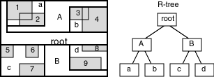
For a layer of geometries, an R-tree index consists of a hierarchical index on the MBRs of the geometries in the layer, as shown in Figure 1-4.
Figure 1-4 R-Tree Hierarchical Index on MBRs

Description of "Figure 1-4 R-Tree Hierarchical Index on MBRs"
In Figure 1-4:
-
1 through 9 are geometries in a layer.
-
a, b, c, and d are the leaf nodes of the R-tree index, and contain minimum bounding rectangles of geometries, along with pointers to the geometries. For example, a contains the MBR of geometries 1 and 2, b contains the MBR of geometries 3 and 4, and so on.
-
A contains the MBR of a and b, and B contains the MBR of c and d.
-
The root contains the MBR of A and B (that is, the entire area shown).
An R-tree index is stored in the spatial index table (SDO_INDEX_TABLE in the USER_SDO_INDEX_METADATA view, described in Spatial Index-Related Structures). The R-tree index also maintains a sequence object (SDO_RTREE_SEQ_NAME in the USER_SDO_INDEX_METADATA view) to ensure that simultaneous updates by concurrent users can be made to the index.
Parent topic: Indexing of Spatial Data
1.7.2 R-Tree Quality
A substantial number of insert and delete operations affecting an R-tree index may degrade the quality of the R-tree structure, which may adversely affect query performance.
The R-tree is a hierarchical tree structure with nodes at different heights of the tree. The performance of an R-tree index structure for queries is roughly proportional to the area and perimeter of the index nodes of the R-tree. The area covered at level 0 represents the area occupied by the minimum bounding rectangles of the data geometries, the area at level 1 indicates the area covered by leaf-level R-tree nodes, and so on. The original ratio of the area at the root (topmost level) to the area at level 0 can change over time based on updates to the table; and if there is a degradation in that ratio (that is, if it increases significantly), rebuilding the index may help the performance of queries.
If the performance of SDO_FILTER operations has degraded, and if there have been a large number of insert, update, or delete operations affecting geometries, the performance degradation may be due to a degradation in the quality of the associated R-tree index.
To rebuild an R-tree index, use the ALTER INDEX REBUILD statement.
Parent topic: Indexing of Spatial Data
