7.1 LRS Terms and Concepts
This topic explains important terms and concepts related to linear referencing support in Oracle Spatial.
- Geometric Segments (LRS Segments)
- Shape Points
- Direction of a Geometric Segment
- Measure (Linear Measure)
- Offset
- Measure Populating
- Measure Range of a Geometric Segment
- Projection
- LRS Point
- Linear Features
- Measures with Multiline Strings and Polygons with Holes
Parent topic: Linear Referencing System
7.1.1 Geometric Segments (LRS Segments)
Geometric segments are basic LRS elements in Oracle Spatial. A geometric segment can be any of the following:
-
Line string: an ordered, nonbranching, and continuous geometry (for example, a simple road)
-
Multiline string: nonconnected line strings (for example, a highway with a gap caused by a lake or a bypass road)
-
Polygon (for example, a racetrack or a scenic tour route that starts and ends at the same point)
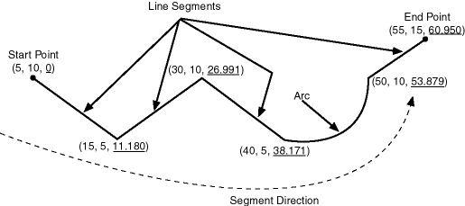
A geometric segment must contain at least start and end measures for its start and end points. Measures of points of interest (such as highway exits) on the geometric segments can also be assigned. These measures are either assigned by users or derived from existing geometric segments. Figure 7-1 shows a geometric segment with four line segments and one arc. Points on the geometric segment are represented by triplets (x, y, m), where x and y describe the location and m denotes the measure (with each measure value underlined in Figure 7-1).
Parent topic: LRS Terms and Concepts
7.1.2 Shape Points
Shape points are points that are specified when an LRS segment is constructed, and that are assigned measure information. In Oracle Spatial, a line segment is represented by its start and end points, and an arc is represented by three points: start, middle, and end points of the arc. You must specify these points as shape points, but you can also specify other points as shape points if you need measure information stored for these points (for example, an exit in the middle of a straight part of the highway).
Thus, shape points can serve one or both of the following purposes: to indicate the direction of the segment (for example, a turn or curve), and to identify a point of interest for which measure information is to be stored.
Shape points might not directly relate to mileposts or reference posts in LRS; they are used as internal reference points. The measure information of shape points is automatically populated when you define the LRS segment using the SDO_LRS.DEFINE_GEOM_SEGMENT procedure, which is described in SDO_LRS Package (Linear Referencing System) .
Parent topic: LRS Terms and Concepts
7.1.3 Direction of a Geometric Segment
The direction of a geometric segment is indicated from the start point of the geometric segment to the end point. The direction is determined by the order of the vertices (from start point to end point) in the geometry definition. Measures of points on a geometric segment always either increase or decrease along the direction of the geometric segment.
Parent topic: LRS Terms and Concepts
7.1.4 Measure (Linear Measure)
The measure of a point along a geometric segment is the linear distance (in the measure dimension) to the point measured from the start point (for increasing values) or end point (for decreasing values) of the geometric segment. The measure information does not necessarily have to be of the same scale as the distance. However, the linear mapping relationship between measure and distance is always preserved.
Some LRS functions use offset instead of measure to represent measured distance along linear features. Although some other linear referencing systems might use offset to mean what the Oracle Spatial LRS refers to as measure, offset has a different meaning in Oracle Spatial from measure, as explained in Offset.
Parent topic: LRS Terms and Concepts
7.1.5 Offset
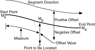
The offset of a point along a geometric segment is the perpendicular distance between the point and the geometric segment. Offsets are positive if the points are on the left side along the segment direction and are negative if they are on the right side. Points are on a geometric segment if their offsets to the segment are zero.
The unit of measurement for an offset is the same as for the coordinate system associated with the geometric segment. For geodetic data, the default unit of measurement is meters.
Figure 7-2 shows how a point can be located along a geometric segment with measure and offset information. By assigning an offset together with a measure, it is possible to locate not only points that are on the geometric segment, but also points that are perpendicular to the geometric segment.
Figure 7-2 Describing a Point Along a Segment with a Measure and an Offset

Description of "Figure 7-2 Describing a Point Along a Segment with a Measure and an Offset"
Parent topic: LRS Terms and Concepts
7.1.6 Measure Populating
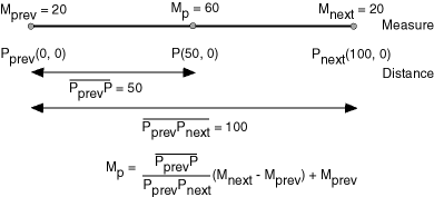
Any unassigned measures of a geometric segment are automatically populated based upon their distance distribution. This is done before any LRS operations for geometric segments with unknown measures (NULL in Oracle Spatial). The resulting geometric segments from any LRS operations return the measure information associated with geometric segments. The measure of a point on the geometric segment can be obtained based upon a linear mapping relationship between its previous and next known measures or locations. See the algorithm representation in Figure 7-3 and the example in Figure 7-4.
Figure 7-3 Measures, Distances, and Their Mapping Relationship

Description of "Figure 7-3 Measures, Distances, and Their Mapping Relationship"
Figure 7-4 Measure Populating of a Geometric Segment

Description of "Figure 7-4 Measure Populating of a Geometric Segment"
Measures are evenly spaced between assigned measures. However, the assigned measures for points of interest on a geometric segment do not need to be evenly spaced. This could eliminate the problem of error accumulation and account for inaccuracy of data source.
Moreover, the assigned measures do not even need to reflect actual distances (for example, they can reflect estimated driving time); they can be any valid values within the measure range. Figure 7-5 shows the measure population that results when assigned measure values are not proportional and reflect widely varying gaps.
Figure 7-5 Measure Populating with Disproportional Assigned Measures

Description of "Figure 7-5 Measure Populating with Disproportional Assigned Measures"
In all cases, measure populating is done in an incremental fashion along the segment direction. This improves the performance of current and subsequent LRS operations.
Parent topic: LRS Terms and Concepts
7.1.7 Measure Range of a Geometric Segment
The start and end measures of a geometric segment define the linear measure range of the geometric segment. Any valid LRS measures of a geometric segment must fall within its linear measure range.
Parent topic: LRS Terms and Concepts
7.1.8 Projection
The projection of a point along a geometric segment is the point on the geometric segment with the minimum distance to the specified point. The measure information of the resulting point is also returned in the point geometry.
Parent topic: LRS Terms and Concepts
7.1.9 LRS Point
LRS points are points with linear measure information along a geometric segment. A valid LRS point is a point geometry with measure information.
All LRS point data must be stored in the SDO_ELEM_INFO_ARRAY and SDO_ORDINATE_ARRAY, and cannot be stored in the SDO_POINT field in the SDO_GEOMETRY definition of the point.
Parent topic: LRS Terms and Concepts
7.1.10 Linear Features
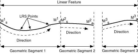
Linear features are any spatial objects that can be treated as a logical set of linear segments. Examples of linear features are highways in transportation applications and pipelines in utility industry applications. The relationship of linear features, geometric segments, and LRS points is shown in Figure 7-6, where a single linear feature consists of three geometric segments, and three LRS points are shown on the first segment.
Figure 7-6 Linear Feature, Geometric Segments, and LRS Points

Description of "Figure 7-6 Linear Feature, Geometric Segments, and LRS Points"
Parent topic: LRS Terms and Concepts
7.1.11 Measures with Multiline Strings and Polygons with Holes
With a multiline string or polygon with hole LRS geometry, the SDO_LRS.DEFINE_GEOM_SEGMENT procedure and SDO_LRS.CONVERT_TO_LRS_GEOM function by default assign the same measure value to the end point of one segment and the start point (separated by a gap) of the next segment, although you can later assign different measure values to points. Thus, by default there will duplicate measure values in different segments for such geometries. In such cases, LRS subprograms use the first point with a specified measure, except when doing so would result in an invalid geometry.
For example, assume that in a multiline string LRS geometry, the first segment is from measures 0 through 100 and the second segment is from measures 100 through 150. If you use the SDO_LRS.LOCATE_PT function to find the point at measure 100, the returned point will be at measure 100 in the first segment. If you use the SDO_LRS.CLIP_GEOM_SEGMENT, SDO_LRS.DYNAMIC_SEGMENT, or SDO_LRS.OFFSET_GEOM_SEGMENT function to return the geometry object between measures 75 and 125, the result is a multiline string geometry consisting of two segments. If you use the same function to return the geometry object between measures 100 and 125, the point at measure 100 in the first segment is ignored, and the result is a line string along the second segment from measures 100 through 125.
Parent topic: LRS Terms and Concepts
