35.75 SDO_UTIL.TILE_GEOMETRY
Format
SDO_UTIL.TILE_GEOMETRY(
  geom                   IN SDO_GEOMETRY,
  x_axis_min             IN NUMBER,
  x_axis_max             IN NUMBER,
  y_axis_min             IN NUMBER,
  y_axis_max             IN NUMBER,
  tile_resolution        IN NUMBER,
  resolution_factor      IN NUMBER   := 0,
  perform_intersection   IN VARCHAR2 := 'TRUE',
  compute_percent        IN VARCHAR2 := 'FALSE',
  geodetic_tolerance     IN NUMBER   := .05)
  RETURN mdsys.tile_geom_table_type DETERMINISTIC
         PIPELINED PARALLEL_ENABLE;
Description
Tiles a geometry based on the specified tile resolution and resolution factor.
Returns MDSYS.TILE_GEOM_TABLE_TYPE, which is a table of
MDSYS.TILE_GEOM_TYPE objects.
Parameters
- geom
-
Geometry to tile.
- x_axis_min
-
Minimum value along the x-axis for tiling domain. (See the Usage Notes for more information.)
- x_axis_max
-
Maximum value along the x-axis for tiling domain. (See the Usage Notes for more information.)
- y_axis_min
-
Minimum value along the y-axis for tiling domain. (See the Usage Notes for more information.)
- y_axis_max
-
Maximum value along the y-axis for tiling domain. (See the Usage Notes for more information.)
- tile_resolution
-
Tile size value. (See the Usage Notes for more information.)
- resolution_factor
-
A value factor applied to the
tile_resolutionparameter.Default value is 0. (See the Usage Notes for more information.)
- perform_intersection
-
A string value of
TRUE(the default) clips boundary tiles to the geometry boundary.A string value of
FALSEreturns full tiles along the geometry boundary. - compute_percent
-
The default string value is
FALSE.A string value of
TRUEcomputes the value between 0 and 1. To compute this valueperform_intersectionmust also be set toTRUE. - geodetic_tolerance
-
Default is
0.05.This parameter is only used if the geometry to tile is longitude/latitude. The default value can be overridden with a value smaller than 0.05.
Usage Notes
SDO_UTIL.TILE_GEOMETRY function can be used to:
- Tile geometries, for example, farm plots or land parcels
- Tile geometries with the tiles that coincide with the cells of a raster.
For raster cell sized tiles, use the extent of the raster as the tiling domain, and set the
tile_resolutionto the raster resolution.
This function returns a table of type
MDSYS.TILE_GEOM_TABLE_TYPE, which is defined as follows:
CREATE OR REPLACE TYPE mdsys.tile_geom_table_type AS TABLE OF tile_geom_type;The object type MDSYS.TILE_GEOM_TYPE, used in the preceding
code, is defined as follows:
CREATE OR REPLACE TYPE mdsys.tile_geom_type AS OBJECT (
  tile_id      NUMBER,
  status       CHAR,
  percent      NUMBER,
  tile_center  SDO_GEOMETRY,
geom SDO_GEOMETRY);MDSYS.TILE_GEOM_TYPE are:
tile_id: A unique number assigned to each tile, beginning with 1.status: The value can be either:'I': for interior tile'B': for boundary tile on the geometry
percent: Percent of tile area coincident with geometry area. Value between 0 and 1. Interior tiles will always return 1.tile_center: Center point of the tile.geom: A geometry tile. If the parameterperform_intersectionisTRUE, boundary tiles are clipped to the geometry boundary.
x_axis_min, x_axis_max,
y_axis_min and y_axis_max used in the
SDO_UTIL.TILE_GEOMETRY function, represent the tiling domain. The tiling
domain is an extent that contains all the geometries that are required to tile. For example,
for longitude/latitude geometries, a tiling domain can be specified using the following
parameter values:
x_axis_min:-180x_axis_max:180y_axis_min:-90y_axis_max:90
The tile_resolution and resolution_factor
parameters influence the tile size as highlighted in the following:
- The desired tile size value is determined by the
tile_resolutionparameter. For example, for a value 5, tiles will be 5x5 or a factor of 5x5 if the parameterresolution_factoris not 0. resolution_factor, when specified, applies a factor to thetile_resolutionparameter, to tile a geometry with either smaller or larger tiles thantile_resolution.The following table describes the tile size as determined by the
resolution_factorvalues:Resolution Factor Value Tile Size 0 (the default) No factor is applied. Tiles size are driven by the tile_resolutionparameter.See Example-1 for more information.
> 0 Tiles generated will be a factor smaller relative to the tile_resolutionparameter. For example, for the followingresolution_factorvalues:- 1: tile size is 1/4 smaller than
tile_resolution - 2: tile size is 1/16 smaller than
tile_resolution - 3: tile size is 1/64 smaller than
tile_resolution
See Example-2 for more information.
< 0 Tiles generated will be a factor larger relative to the tile_resolutionparameter. For example, for the followingresolution_factorvalues:- -1: tile size is 4 times larger than
tile_resolution - -2: tile size is 16 times larger than
tile_resolution - -3: tile size is 64 times larger than
tile_resolution
See Example-3 for more information.
However, when generating tiles, smaller tiles will be fully contained by larger tiles. Also, tiles generated with different resolutions, larger or smaller, will always be aligned.
- 1: tile size is 1/4 smaller than
Examples
The following examples tile geometries with the tiles that coincide with the
cells of a raster. Also, the raster extent is projected (not longitude, latitude), so the
domain extent is set to the extent of the raster. The parameter,
perform_intersection => 'TRUE' in the examples, causes clipping of the
boundary tiles to the boundary of the farm.
Example 1
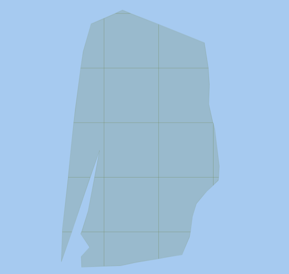
This example tiles a farm geometry with tiles that are equal to the size of a raster cell. The resolution of the raster is 1000, so tiles will be 1000x1000
WITH
  part0 AS (SELECT b.tile_id,
                   b.status,
                   b.percent,
                   b.tile_center,
                   b.geom
            FROM farm_plots a,
            TABLE (sdo_util.tile_geometry(geom                 => a.geom,
                                          x_axis_min           => 272039.5,
                                          x_axis_max           => 275188.5,
                                          y_axis_min           => 370575.5,
                                          y_axis_max           => 380165.5,
                                          tile_resolution      => 1000,
                                          resolution_factor    => 0,
                                          perform_intersection => 'TRUE',
                                          compute_percent      => 'TRUE',
                                          geodetic_tolerance   => NULL)) b
            WHERE a.id = -1)
 SELECT tile_id, geom FROM part0 ORDER BY tile_id;
The following figure depicts the resulting output:
Figure 35-2 Tile size same as
tile_resolution

Description of "Figure 35-2 Tile size same as tile_resolution"
Example 2
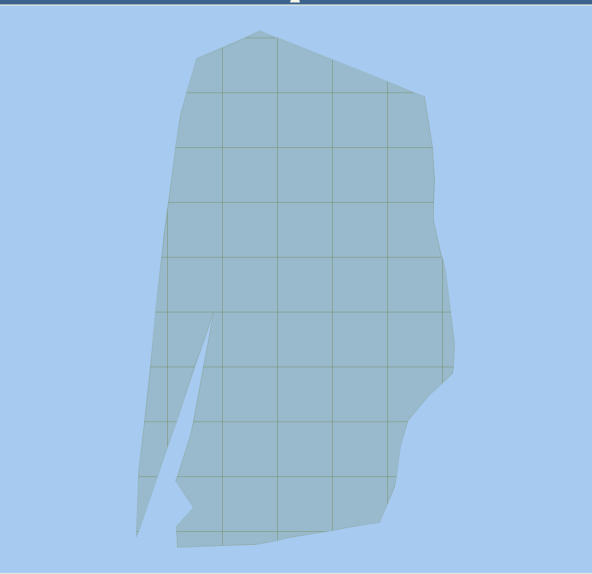
The following example tiles a farm geometry with tiles that are 1/4 times
smaller than 1000 x 1000, because resolution_factor => 1 is
specified.
WITH
  part0 AS (SELECT b.tile_id,
                   b.status,
                   b.percent,
                   b.tile_center,
                   b.geom
            FROM farm_plots a,
            TABLE (sdo_util.tile_geometry(geom                 => a.geom,
                                          x_axis_min           => 272039.5,
                                          x_axis_max           => 275188.5,
                                          y_axis_min           => 370575.5,
                                          y_axis_max           => 380165.5,
                                          tile_resolution      => 1000,
                                          resolution_factor    => 1,
                                          perform_intersection => 'TRUE',
                                          compute_percent      => 'TRUE',
                                          geodetic_tolerance   => NULL)) b
            WHERE a.id = -1)
 SELECT tile_id, geom FROM part0 ORDER BY tile_id;
The following figure depicts the resulting output:
Figure 35-3 Tile size smaller than
tile_resolution

Description of "Figure 35-3 Tile size smaller than tile_resolution"
Example 3
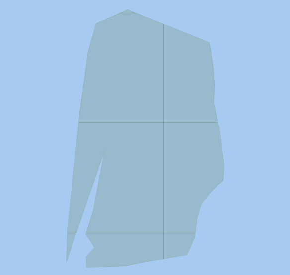
The following example tiles a farm geometry with tiles that are 4 times greater
than 1000 x 1000, because resolution_factor => -1 is specified.
WITH
  part0 AS (SELECT b.tile_id,
                   b.status,
                   b.percent,
                   b.tile_center,
                   b.geom
            FROM farm_plots a,
            TABLE (sdo_util.tile_geometry(geom                 => a.geom,
                                          x_axis_min           => 272039.5,
                                          x_axis_max           => 275188.5,
                                          y_axis_min           => 370575.5,
                                          y_axis_max           => 380165.5,
                                          tile_resolution      => 1000,
                                          resolution_factor    => -1,
                                          perform_intersection => 'TRUE',
                                          compute_percent      => 'TRUE',
                                          geodetic_tolerance   => NULL)) b
            WHERE a.id = -1)
 SELECT tile_id, geom FROM part0 ORDER BY tile_id;
The following figure depicts the resulting output:
Figure 35-4 Tile size greater than
tile_resolution

Description of "Figure 35-4 Tile size greater than tile_resolution"
Parent topic: SDO_UTIL Package (Utility)