1.4 Topology Geometry Layer Hierarchy
In some topologies, the topology geometry layers (feature layers) have one or more parent-child relationships in a topology hierarchy. That is, the layer at the topmost level consists of features in its child layer at the next level down in the hierarchy; the child layer might consist of features in its child layer at the next layer farther down; and so on.
For example, a land use topology might have the following topology geometry layers at different levels of hierarchy:
-
States at the highest level, which consists of features from its child layer, Counties
-
Counties at the next level down, which consists of features from its child layer, Tracts
-
Tracts at the next level down, which consists of features from its child layer, Block Groups
-
Block Groups at the next level down, which consists of features from its child layer, Land Parcels
-
Land Parcels at the lowest level of the hierarchy
If the topology geometry layers in a topology have this hierarchical relationship, it is far more efficient if you model the layers as hierarchical than if you specify all topology geometry layers at a single level (that is, with no hierarchy). For example, it is more efficient to construct SDO_TOPO_GEOMETRY objects for counties by specifying only the tracts in the county than by specifying all land parcels in all block groups in all tracts in the county.
The lowest level (for the topology geometry layer containing the smallest kinds of features) in a hierarchy is level 0, and successive higher levels are numbered 1, 2, and so on. Topology geometry layers at adjacent levels of a hierarchy have a parent-child relationship. Each topology geometry layer at the higher level is the parent layer for one layer at the lower level, which is its child layer. A parent layer can have only one child layer, but a child layer can have one or more parent layers. Using the preceding example, the Counties layer can have only one child layer, Tracts; however, the Tracts layer could have parent layers named Counties and Water Districts.
Note:
Topology geometry layer hierarchy is somewhat similar to network hierarchy, which is described in Network Hierarchy; however, there are significant differences, and you should not confuse the two. For example, the lowest topology geometry layer hierarchy level is 0, and the lowest network hierarchy level is 1; and in a topology geometry layer hierarchy each parent must have one child and each child can have many parents, while in a network hierarchy each parent can have many children and each child must have one parent.
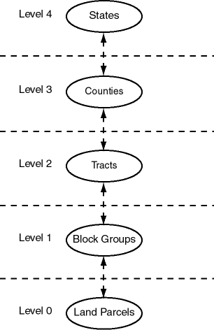
Figure 1-4 shows the preceding example topology geometry layer hierarchy. Each level of the hierarchy shows the level number and the topology geometry layer in that level.
Figure 1-4 Topology Geometry Layer Hierarchy

Description of "Figure 1-4 Topology Geometry Layer Hierarchy"
Example 1-2 Modeling a Topology Geometry Layer Hierarchy
To model topology geometry layers as hierarchical, specify the child layer in the child_layer_id parameter when you call the SDO_TOPO.ADD_TOPO_GEOMETRY_LAYER procedure to add a parent topology geometry layer to the topology. Add the lowest-level (level 0) topology geometry layer first; then add the level 1 layer, specifying the level 0 layer as its child; then add the level 2 layer, specifying the level 1 layer as its child; and so on. Example 1-2 shows five topology geometry layers being added so that the 5-level hierarchy is established.
-- Create the topology. (Null SRID in this example.)
EXECUTE SDO_TOPO.CREATE_TOPOLOGY('LAND_USE_HIER', 0.00005);

-- Create feature tables.
CREATE TABLE land_parcels ( -- Land parcels (selected faces)
  feature_name VARCHAR2(30) PRIMARY KEY,
  feature SDO_TOPO_GEOMETRY);

CREATE TABLE block_groups (
  feature_name VARCHAR2(30) PRIMARY KEY,
  feature SDO_TOPO_GEOMETRY);

CREATE TABLE tracts (
  feature_name VARCHAR2(30) PRIMARY KEY,
  feature SDO_TOPO_GEOMETRY);

CREATE TABLE counties (
  feature_name VARCHAR2(30) PRIMARY KEY,
  feature SDO_TOPO_GEOMETRY);

CREATE TABLE states (
  feature_name VARCHAR2(30) PRIMARY KEY,
  feature SDO_TOPO_GEOMETRY);

-- (Other steps not shown here, such as populating the feature tables
-- and initializing the metadata.)
. . .
-- Associate feature tables with the topology; include hierarchy information.

DECLARE
  land_parcels_id NUMBER;
  block_groups_id NUMBER;
  tracts_id NUMBER;
  counties_id NUMBER;
BEGIN
SDO_TOPO.ADD_TOPO_GEOMETRY_LAYER('LAND_USE_HIER', 'LAND_PARCELS',
  'FEATURE','POLYGON');
SELECT tg_layer_id INTO land_parcels_id FROM user_sdo_topo_info
  WHERE topology = 'LAND_USE_HIER' AND table_name = 'LAND_PARCELS';
SDO_TOPO.ADD_TOPO_GEOMETRY_LAYER('LAND_USE_HIER', 'BLOCK_GROUPS',
  'FEATURE','POLYGON', NULL, land_parcels_id);
SELECT tg_layer_id INTO block_groups_id FROM user_sdo_topo_info
  WHERE topology = 'LAND_USE_HIER' AND table_name = 'BLOCK_GROUPS';
SDO_TOPO.ADD_TOPO_GEOMETRY_LAYER('LAND_USE_HIER', 'TRACTS',
  'FEATURE','POLYGON', NULL, block_groups_id);
SELECT tg_layer_id INTO tracts_id FROM user_sdo_topo_info
  WHERE topology = 'LAND_USE_HIER' AND table_name = 'TRACTS';
SDO_TOPO.ADD_TOPO_GEOMETRY_LAYER('LAND_USE_HIER', 'COUNTIES',
  'FEATURE','POLYGON', NULL, tracts_id);
SELECT tg_layer_id INTO counties_id FROM user_sdo_topo_info
  WHERE topology = 'LAND_USE_HIER' AND table_name = 'COUNTIES';
SDO_TOPO.ADD_TOPO_GEOMETRY_LAYER('LAND_USE_HIER', 'STATES',
  'FEATURE','POLYGON', NULL, counties_id);
END;/
Within each level above level 0, each layer can contain features built from features at the next lower level (as is done in Example 1-2), features built from topological elements (faces, nodes, edges), or a combination of these. For example, a tracts layer can contain tracts built from block groups or tracts built from faces, or both. However, each feature within the layer must be built only either from features from the next lower level or from topological elements. For example, a specific tract can consist of block groups or it can consist of faces, but it cannot consist of a combination of block groups and faces.
To insert or update topology geometry objects in feature tables for the levels in a hierarchy, use the appropriate forms of the SDO_TOPO_GEOMETRY constructor. Feature tables are described in Topology Geometries and Layers, and SDO_TOPO_GEOMETRY constructors are described in SDO_TOPO_GEOMETRY Constructors.
Note that the TOPO_ID and TOPO_TYPE attributes in the relationship information table have special meanings when applied to parent layers in a topology with a topology geometry layer hierarchy. See the explanations of these attributes in Table 1-5 in Relationship Information Table.
Parent topic: Topology Data Model Overview