3.6 Spatial Studio Datasets Page
The Datasets page lets you view and edit existing datasets, and also create new ones.
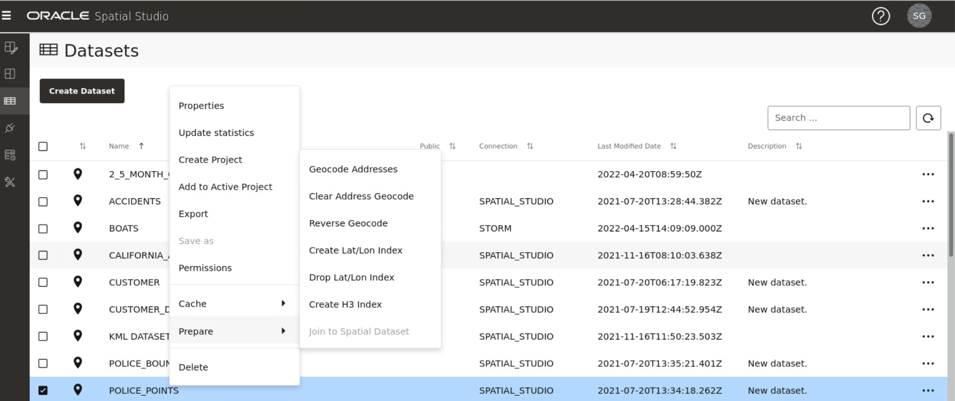
The following figure shows the Datasets page:
Datasets that are displayed on the Datasets page belong to one of the following two categories:
- Manually created by clicking Create Dataset or when you perform a Save as operation with the Create Dataset option enabled. This dataset can then be added to the project for visualization.
- Automatically created when you perform spatial analysis, save selected
features, or store pins as a map layer.
This dataset gets instantly added to the map visualization and also appears listed in the Datasets page. Such a dataset is known as a spatial analysis dataset.
You can perform the following actions on the Datasets page:
- You can manually create a new dataset, by clicking Create Dataset.
- By clicking
 against any displayed dataset or by right-clicking a dataset row, you can
perform the following actions:
- Properties: View or modify properties of the dataset
- Update Statistics: Update the dataset statistics (refer to Updating Statistics for Datasets)
- Create Project: Create a new project using the dataset
- Add to Active Project: Add the dataset to the project in the Active Project page
- Export: Export the dataset (in GeoJSON or CSV file format)
- Save as: Make a new copy of the dataset
- Permissions: Configure dataset sharing and permissions
- Cache: Control map tiles pre-caching activities (refer to About Cache in Spatial Studio)
- Prepare: Prepare a dataset for any of the following
options:
- Geocode Addresses: Add geocoded information such as geographic coordinates to the dataset
- Clear Address Geocode: Remove geocoded information from the dataset
- Reverse Geocode: Add address information from a set of geographic coordinates to the dataset
- Create Lat/Lon Index: Create latitude/longitude index
- Drop Lat/Lon Index: Remove latitude/longitude index
- Create H3 Index: Prepare an H3 aggregation dataset
- Join to Spatial Dataset: Prepare a non-spatial dataset for map visualization by joining to a spatial dataset
- Delete: Delete the dataset
- About Creating a Dataset From the Datasets Page
Spatial Studio allows you to create different types of datasets from the Datasets page. - About Spatial Analysis Datasets
Spatial Studio stores the results of a spatial analysis operation in a spatial analysis dataset. Also, storing selected geographic features or pins on a map layer gets saved as a new spatial analysis dataset. - Datasets with Issues
All datasets in Spatial Studio must meet certain data requirements in order to be used for map visualization and analysis. - Geocoding a Dataset
Geocoding is the process of deriving the latitude and longitude coordinates from location details that are geo address types. - Reverse Geocoding a Dataset
Reverse geocoding is the process of deriving the address information from a set of latitude and longitude coordinates. - Preparing a Non-Spatial Dataset for Analysis
Spatial Studio allows you to prepare a non-spatial dataset for mapping and analysis by joining to a spatial dataset. - Exporting a Dataset to GeoJSON
You can export a dataset from Spatial Studio to GeoJSON. - Updating Statistics for Datasets
The Update statistics feature in Spatial Studio gathers statistics of the dataset columns. - About Cache in Spatial Studio
Starting with Spatial Studio release 22.3, all vector tiles generated for all datasets are cached to the file system by default.
Parent topic: Using Oracle Spatial Studio
