Integration Processes and Workflows
This integration supports three primary synchronization workflows:
Asset and Location Inbound Synchronization
This file-based integration workflow is available in Oracle Utilities Work and Asset Cloud Service V25.4 and later.
Flow: ArcGIS > OIC > Object Storage > WACS
In this process, Oracle Integration Cloud extracts asset and location data from ArcGIS and generates newline-delimited GeoJSON files. These files are placed in Object Storage for Oracle Utilities Work and Asset Cloud Service processing.
Oracle Utilities Work and Asset Cloud Service then processes files to create or update asset and location records.
Asset Outbound Synchronization
This file-based integration workflow is available in Oracle Utilities Work and Asset Cloud Service V25.10 and later.
Flow: WACS > Object Storage/FTP > OIC > ArcGIS
When asset updates occur in Oracle Utilities Work and Asset Cloud Service, the asset data is exported as files to object storage. It is then processed by Oracle Integration Cloud to ESRI ArcGIS.
Work Location Synchronization
This real-time messaging integration workflow is available in Oracle Utilities Work and Asset Cloud Service V26.4 and later.
Flow: WACS > Outbound Message > OIC > ArcGIS > OIC > WACS
When a work location is created in Oracle Utilities Work and Asset Cloud Service, an outbound message is sent to Oracle Integration Cloud. Oracle Integration Cloud coordinates the creation of the corresponding work location feature in ArcGIS. After ArcGIS creates the feature, the generated Global ID is returned to Oracle Integration Cloud and stored on the work location record in Oracle Utilities Work and Asset Cloud Service.
Required Batch Processes
The Work Location Synchronization process uses real-time messaging and does not require batch processing.
Inbound Synchronization: ArcGIS to WACS
The following batch processes are required for the file-based Asset and Location Inbound Synchronization flow:
Step | Batch Code | Description | Parameters |
|---|---|---|---|
1 | W1GISUPL | GIS File Upload This batch processes the GeoJSON newline-delimited files (geojsonl file extension) and creates composite synchronization requests. Note: Access to the GIS File Upload (W1GISUPL) application service is needed to run this batch job. | File Name: *.geosjonl File Path: Object Storage Location |
2 | W1-CMSYN | Composite Sync Request This batch generates two new synchronization requests per record —one for asset locations and one for assets. | State: PENDING BO: W1-CompositeSyncReqGISAsset |
3 | W1-SIOPE | Ongoing Sync Request - Pending This batch creates or updates asset locations as needed. | State: PENDING BO: W1-OngoingSyncRequestLocation |
4 | W1-SIOPE | Ongoing Sync Request - Pending This batch creates or updates assets as needed. | State: PENDING BO: W1-OngoingSyncRequestAsset |
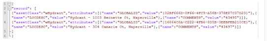
Sample file for W1GISUPL: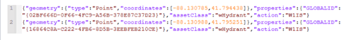
Outbound Synchronization: WACS to ArcGIS
The following batch processes are required for the file-based Asset Outbound Synchronization flow:
Step | Batch Code | Description | Parameters |
|---|---|---|---|
1 | W1GISEXT | GIS File Extract When an asset update occurs, an entry is added to the General Process table for the asset. This batch extracts the relevant asset records and uploads data files to object storage for OIC processing. Note: Access to the GIS File Extract (W1GISEXT) application service is needed to run this batch job. | File Name: WACS_<assetClass>_{BN}_ {RN}_{TN}.json File Path: Object Storage Location |
Sample file: