Use Maps to Create Explorations

You can use maps to set up alerts for your IoT application. Whenever a device enters or exits the defined boundaries, the you can be alerted .

Ensure that you have already defined at least one map using the information in Create a New Map before you proceed with the following steps.
To create explorations using maps:
  1. In the Explorations section of the Data and Explorations page, click Add.
  2. In the Exploration Type text field, select Spatial General from the list of Patterns.
  3. Enter a value in the Exploration Name text field.
  4. Click Confirm.
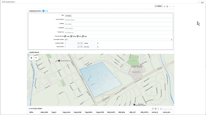
    The Edit Exploration page is displayed, similar to the following image:Description of edit-map-exploration.jpg follows
    Description of the illustration edit-map-exploration.jpg
  5. Click in Map and select from the list of maps you’ve created earlier.
  6. Click in Event Stream field, and select from the list of available sources.
  7. Select a field to be used for Latitude.
  8. Select a field to be used for Longitude for the spatial.
  9. Select a field to be used as the Object Key.
    The object key, latitude, and longitude determine the way spatial pattern recognizes data from the incoming messages and correlatse them with the geo-fences in the map.
     Typically the Object Key is the message_source or a field that identifies a device uniquely.
  10. Select the options for Tracking Events. This field determines the proximity of the location for the pattern. The possible values are:
    • Near - whenever a new event occurs in the defined spatial region defined by the specified latitude and longitude.

    • Enter - whenever an existing event enters the spatial region defined by the specified latitude and longitude.

    • Exit - whenever an event exits the spatial region defined by the specified latitude and longitude.

    • Stay - when an event stays (the duration is specified in step 11) in the spatial region defined by the specified latitude and longitude.

  11. Select the Coordinate System ID from the list.
    The possible values are:
    • 3857 - also known as WGS 84/Pseudo-Mercator. This is a geodetic projected Cartesian 2d coordinate system

    • 8307 - also known as Longitude/Latitude (WGS 84). This an Elipsoidal 2d coordinate system. This coordinate system is introduced by Oracle and is used by default.

  12. Enter a numerical value greater than zero for the Distance Buffer. This field is enabled only when you select Near in Tracking Events.
  13. Enter a numerical value greater than zero for the Stay Duration. This field is enabled only when you select Stay in Tracking Events
The exploration is now visually represented in the Spatial Results section in the form of a map that’s based on the data you have specified in the previous fields.