1.5 Bands, Layers, and Metadata
In GeoRaster, band and layer are different concepts.
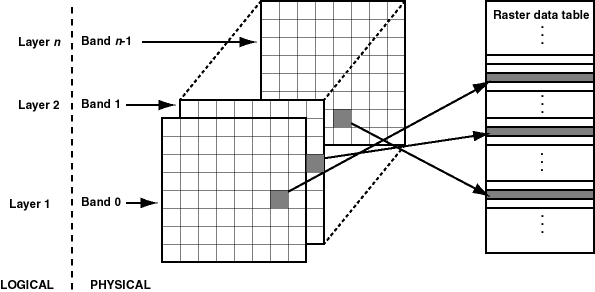
Band is a physical dimension of the multidimensional raster data set; that is, it is one ordinate in the cell space. For example, the cell space might have the ordinates row, column, and band. Bands are numbered from 0 to n-1, where n is the highest layer number. Layer is a logical concept in the GeoRaster data model. Layers are mapped to bands. Typically, one layer corresponds to one band, and it consists of a two-dimensional matrix of size rowDimensionSize and columnDimensionSize. Layers are numbered from 1 to n; that is, layerNumber = bandNumber + 1.
A GeoRaster object can contain multiple bands, which can also be called multiple layers. For example, electromagnetic wave data from remote sensing devices is grouped into a certain number of channels, where the number of possible channels depends on the capabilities of the sensing device. Multispectral images contain multiple channels, and hyperspectral images contain a very large number (say, 50 or more) of channels. The channels are all mapped into GeoRaster bands, which are associated with layers.
In raster GIS applications, a data set can contain multiple raster layers, and each layer is called a theme. For example, a raster may have a population density layer, where different cell values are used to depict neighborhoods or counties depending on their average number of inhabitants per square mile or kilometer. Other examples of themes might be average income levels, land use (agricultural, residential, industrial, and so on), and elevation above sea level. The raster GIS themes can be stored in different GeoRaster objects or in one GeoRaster object, and each theme is modeled as one layer. The raster themes and multispectral image channels can also be stored together in one GeoRaster object as different layers, as long as they have the same dimensions.
Figure 1-5 shows an image with multiple layers and a single raster data table. Each layer contains multiple blocks, each of which typically contains many cells. Each block has an entry in the raster data table. Note that GeoRaster starts layer numbering at 1 and band numbering at 0 (zero), as shown in Figure 1-5.
Figure 1-5 Layers, Bands, and the Raster Data Table

Description of "Figure 1-5 Layers, Bands, and the Raster Data Table"
The GeoRaster XML metadata refers to the object layer and to layers. The object layer refers to the whole GeoRaster object, which may or may not contain multiple layers. If the GeoRaster object contains multiple layers, each layer is a sublayer of the object layer, and it refers to a single band.
Each layer can have an optional set of metadata associated with it. The metadata items for a layer include the user-defined layer ID, description, bitmap mask, NODATA values and value ranges, scaling function, bin function, statistical data set (including histogram), grayscale lookup table, and colormap (or, pseudocolor lookup table, also called a PCT). The metadata items are defined in the GeoRaster metadata XML schema, which is presented in GeoRaster Metadata XML Schema. the SDO_GEOR_HISTOGRAM object type in SDO_GEOR_HISTOGRAM Object Type, the SDO_GEOR_COLORMAP object type in SDO_GEOR_COLORMAP Object Type, SDO_GEOR_GRAYSCALE object type in SDO_GEOR_GRAYSCALE Object Type, and the SDO_GEOR_SRS object type in SDO_GEOR_SRS Object Type.
The metadata associated with the object layer applies to the whole GeoRaster object. The metadata associated with a layer applies only to that layer. For example, the statistical data set for the object layer is calculated based on all cells of the GeoRaster object, regardless of how many layers the object has; but the statistical data for a layer is calculated based only on the cells in that layer.
The metadata for the object layer and other layers is stored using <layerInfo> elements in the GeoRaster XML metadata and sometimes in separate tables, such as a colormap table or a histogram table. Metadata stored in the GeoRaster XML metadata is managed by GeoRaster, and you can use the GeoRaster API to retrieve and modify this metadata. For metadata stored in separate tables, the table name can be registered in the GeoRaster XML schema, in which case applications can retrieve the name of the table. However, GeoRaster does not check the existence or validity of that table or provide any operations on that table.
Three types of interleaving are supported: BSQ (band sequential), BIL (band interleaved by line), and BIP (band interleaved by pixel). Interleaving applies between bands or layers only. Interleaving is limited to the interleaving of cells inside each block of a GeoRaster object. This means GeoRaster always applies blocking on a GeoRaster object first, and then it applies interleaving inside each block independently. However, each block of the same GeoRaster object has the same interleaving type. You can change the interleaving type of a copy of a GeoRaster object by calling SDO_GEOR.changeFormatCopy procedure, so that the data can be more efficiently processed and used.
Parent topic: GeoRaster Overview and Concepts