- Guide
- Using Oracle Spatial Studio
- Visualization in Oracle Spatial Studio
- Styling a Map Layer
- Applying Style for a GeoRaster Layer
3.10.4.2 Applying Style for a GeoRaster Layer
You can style a GeoRaster map layer using the following steps.
The instructions assume that you have a GeoRaster map layer displayed on your
Active Project page.
- Click
 against the dataset in the Data tab of the Layers
list.
 - Select Settings in the context menu.The Layer Settings panel opens.
- Optionally, modify any of the following options in the Style:
- Opacity
- Maximum Brightness
- Minimum Brightness
- Saturation
- Contrast
- Hue Rotate
- Fade Duration
- Optionally, modify any of the following rendering options in the Raster
tab:
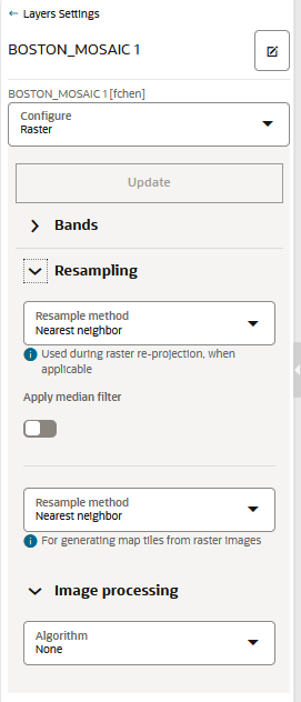
Figure 3-62 Raster Configuration for GeoRaster Map Layer

Description of "Figure 3-62 Raster Configuration for GeoRaster Map Layer"- Bands:
Spatial Studio, by default supports
the following bands:
- Red
- Blue
- Green
- Alpha
For GeoRaster images that have more than three layers, you can choose which three layers you want to visualize.
- Resampling: The following two types of resampling
processes are supported:
- Image Reprojection: This represents the interpolation method to be used when transforming an image from one SRS (Spatial Reference System) to another. This applies only if the SRS of the source image in the database table is different from Spatial Studio's base map projection.
- Map Image Tile Generation: This represents
the image interpolation value that determines how each image
cell's value on a view port is interpolated using the original
image pixels. During an image tile generation, resampling occurs
(although the provided images are in the same SRS) as the
spatial resolution of the two images may be different.
The following interpolation algorithm options are supported:
- NEAREST NEIGHBOR: This option has no interpolation by taking the nearest image pixel's value directly.
- BI-LINEAR: This option will consider 4 neighboring pixels to determine the image cell's value.
- CUBIC: This option uses cubic convolution function to estimate image cell's value. Since a 4x4 neighboring pixels participate in the interpolation, it results in a smoother image.
- Image Processing: represents the subprogram to be used to enhance the visual quality of the images.
The GeoRaster map layer is rendered with the updated settings. - Bands:
Spatial Studio, by default supports
the following bands:
Parent topic: Styling a Map Layer