3.6.5 Reverse Geocoding a Dataset

Reverse geocoding is the process of deriving the address information from a set of latitude and longitude coordinates.

You can reverse geocode a dataset in Spatial Studio to add address information to the dataset's table using the following steps.

Note:

Reverse Geocoding is supported only in point or latitude and longitude datasets.
The instructions assume that a dataset containing the coordinates details is already existing in your database schema.
  1. Navigate to the Datasets page.
  2. Right-click on the dataset name on which you want to apply reverse geocoding.
  3. Select Reverse Geocode from the Prepare context menu.
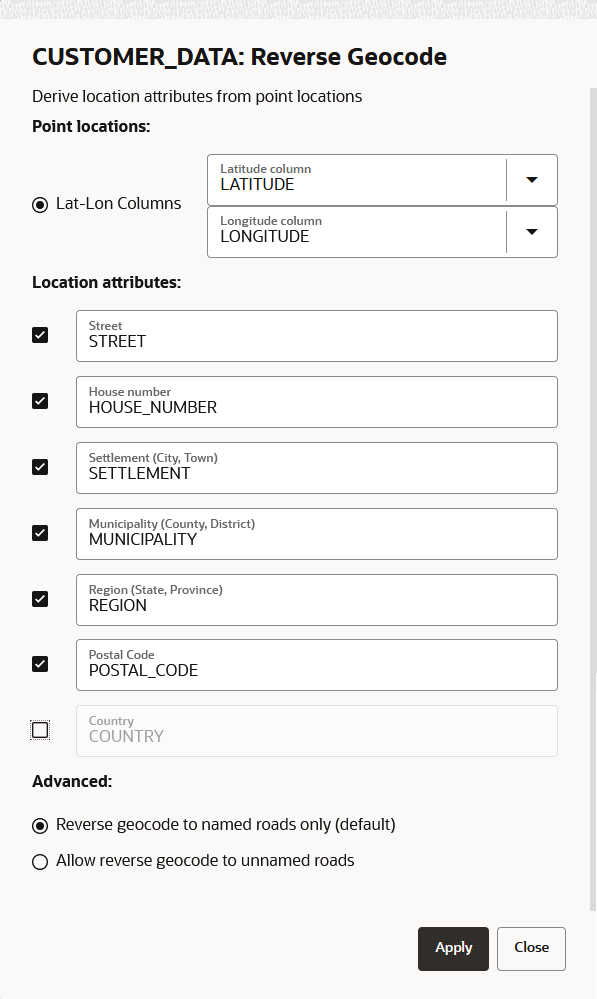
  4. Optionally, select and modify the required Location attributes as shown in Figure 3-22.
    The Input text fields for Location attributes are the column names to be created in the underlying database table for the target dataset.
  5. Select the Advanced option as required.
    The default Reverse geocode to named roads only option ensures that for all latitude and longitude coordinates that do not match a named road, the closest street or road name will be obtained while geocoding.
  6. Click Apply.
    You can monitor the Reverse geocode dataset background task on the Jobs page. A successful completion of the job indicates that reverse geocoding is applied for the data in the dataset.
    You can verify that reverse geocoding has been applied to your dataset by viewing the additional address related columns in the dataset properties.