FSM Task Address and Coordinates
In Field Service Management (FSM), task and project task records use an address and coordinates for maps, navigation, and on-site checks. For the map and tracking context, see FSM Maps and Location Tracking.
The following table lists the address and coordinate fields used by task and project task records.
|
Field Name |
Field ID |
Feature Use |
|---|---|---|
|
Field Service Address |
|
Address used for coordinate lookup and the default external map link. |
|
Field Service Latitude |
|
Latitude used for the task marker, route destination, and on-site distance calculation. |
|
Field Service Longitude |
|
Longitude used with latitude for the same purposes. |
|
Field Service Geolocation |
|
Combined |
Task Coordinate Calculation from an Address
Address geocoding means looking up an address to obtain latitude and longitude. When automatic geocoding is enabled and its dependencies are available, the following table describes how FSM populates task and project task fields.
|
Scenario |
FSM Behavior |
|---|---|
|
Enter or change a nonempty Field Service Address on the NetSuite task or project task form |
Requests coordinates for the address without requiring existing latitude and longitude to be cleared. A usable lookup result populates Field Service Latitude, Field Service Longitude, and Field Service Geolocation. |
|
Open a form for creating or copying a record, or save the form, with an address and both latitude and longitude empty |
Can request coordinates from the address. If either coordinate already has a value, this initialization or form-save check leaves the coordinates unchanged. |
|
Submit a create or edit operation outside the form, or an inline update |
Requests coordinates only when Field Service Address changes and neither Field Service Latitude nor Field Service Longitude changes in the same submission. Changing or clearing coordinate values in that submission suppresses this automatic lookup. |
|
Clear Field Service Address |
The address-geocoding handler performs no lookup and does not clear existing coordinates. |
Changing the address on a task or project task form requests coordinates without requiring old coordinates to be cleared. A submission outside the form additionally requires no latitude or longitude changes in the same submission. The following diagram compares the coordinate lookup flows:
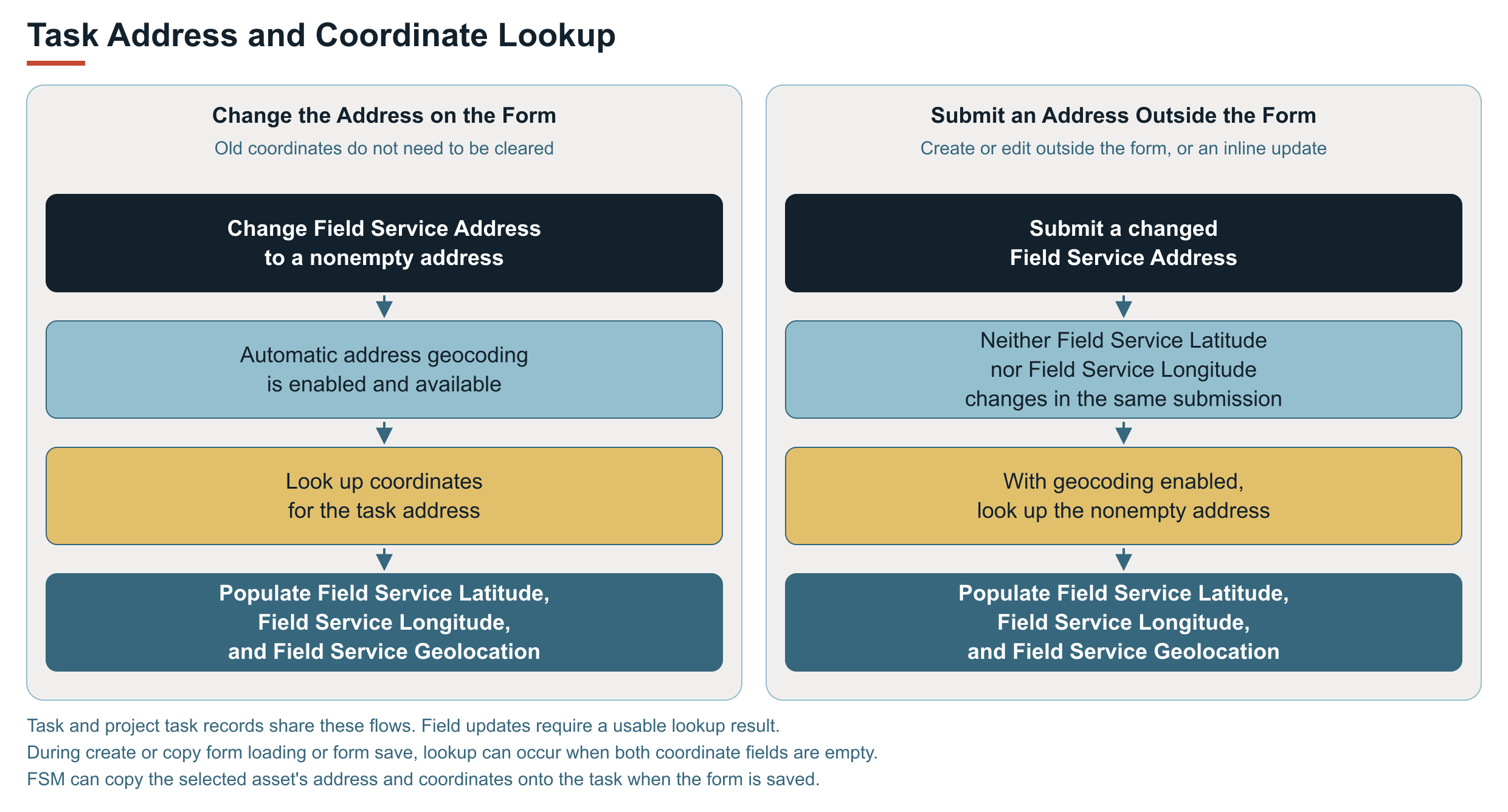
For example, on a task form, you can replace Field Service Address with a different address even if the old coordinates remain populated. FSM can calculate replacement coordinates from the changed address. Clearing the address and coordinates first is not a prerequisite. The fields populated on the form are persisted when the record is saved. Copying values from a selected asset, described in Address and Coordinate Copying from a Selected Asset, can affect the final values.
Address and Coordinate Copying from a Selected Asset
If Field Service Task Asset (custevent_nx_task_asset) is populated, FSM can copy that asset's address, latitude, and longitude into the task or project task fields. This copying occurs:
-
During form loading for record creation or copying.
-
When the selected asset changes on the form.
-
When the form is saved.
-
During create or edit submission outside the form.
The save-time copy can replace task address or coordinate edits with the selected asset's values.
The resulting task or project task latitude and longitude are the coordinates used for its marker, route destination, and on-site checks. For asset setup, see Setting Up Field Service Assets.
Task Display with Existing Coordinates
When the map loads task or project task data, it reads the available Field Service Latitude and Field Service Longitude. Displaying a marker does not itself look up the address. The coordinates may already have been calculated from the task address, copied from the selected asset, or entered on the task.
A valid map position requires both latitude and longitude. Latitude must be between -90 and 90, and longitude must be between -180 and 180. These ranges include 0. One coordinate is insufficient for a valid map position. However, an existing coordinate value can prevent the initialization or form-save lookup described in Task Coordinate Calculation from an Address.
For asset location sources and propagation of later location changes, see FSM Service Locations and Geocoding.